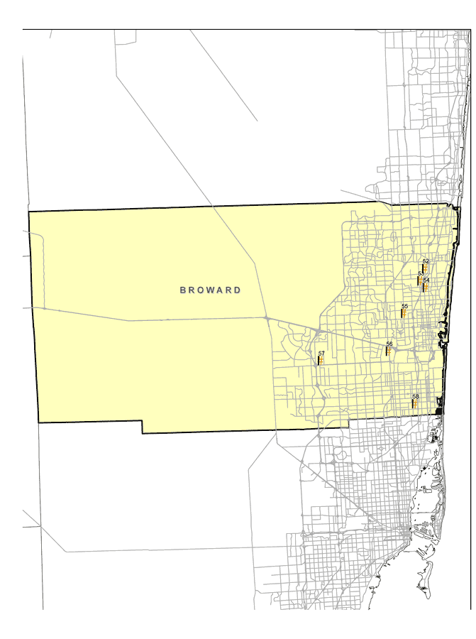
Description: This map shows the locations of Broward County's seven Superfund Sites listed on the United States Environmental Protection Agency's National Priorities List (NPL). The map was created based on Environmental Protection Agency (EPA) shapefiles and metadata. Full information about each site, including each site history, narrative, and Agency for Toxic Substances and Disease Registry (ATSDR) information can be found on the U.S. EPA website. The site name, latitude/longitude, and NPL status for the Broward sites are:| 52 | Wilson Concepts of Florida, Inc.
1408 SW 8th Street
Pompano Beach, FL 33069 | NPL: Deleted from NPL
Latitude: 26.218675
Longitude: -80.142768 | | 53 | Hollingsworth Solderless Terminal
700 NW 57th Place
Fort Lauderdale, FL 33309 | NPL: On final NPL
Latitude: 26.198331
Longitude: -80.152219 | | 54 | Chemform, Inc.
1410 SW 8th St.
Pompano Beach, FL 33069 | NPL: Deleted from NPL
Latitude: 26.18675
Longitude: -80.142805 | | 55 | Wingate Road Municipal Incinerator Dump
1300 N. W. 34th Avenue
Fort Lauderdale, FL 33311 | NPL: On final NPL
Latitude: 26.1444
Longitude: -80.1847 | | 56 | Florida Petroleum Reprocessors
3211 S. W. 50th Avenue
Fort Lauderdale, FL 33314 | NPL: On final NPL
Latitude: 26.081944
Longitude: -80.215556 | | 57 | Davie Landfill
SW 142nd Ave.
Davie, FL 33314 | NPL: On final NPL
Latitude: 26.0696
Longitude: -80.3426 | | 58 | Petroleum Products Corp.
14000 Block Pembroke Road
Pembroke Park, FL 33024 | NPL: On final NPL
Latitude: 25.9926
Longitude: -80.1696 |
Place Names: Broward, Davie, Ft. Lauderdale
ISO Topic Categories: environment, health, inlandWaters, society
Keywords: Broward EPA Superfund Sites, physical, political, Hazardous Waste Sitephysical features, county borders, environment, health, inlandWaters, society, Albers_Conical_Equal,2008
Source: Florida Center for Instructional Technology, (Tampa, FL: FCIT, 2008)
Map Credit: Courtesy Roy Winkelman |
|