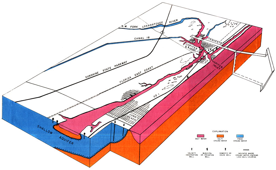
Description: This is a map showing the encroaching salt water in northeast Palm Beach County, current to 1973. It also shows cities, roads, railroads and inland water. Blue is fresh water, pink is salt water and orange is salty ground-water. "Today (1972) sea water encroaches the coast. Wedges of salty ground water threaten municipal wells and other wells in Juno Beach, Tequesta and Jupiter, while salt-water tides invade the Loxahatchee River. Declining ground-water levels and diminishing streamflow permit sea water to move inland beneath fresh ground water as well as into the Loxahatchee. The shallow aquifer shown above is about 200 feet thick and underlies the eastern part of Palm Beach and Martin counties." — Florida Bureau of Geology It is connected to a map of the Tequesta Well Field which you can find here. Please see the article Encroaching Salt Water in Northeast Palm Beach County by Harry G. Rodis for more information.
Place Names: Palm Beach, Loxahatchee River, Tequesta, Atlantic Ocean, Jupiter Inlet, Jupiter, Juno Beach
ISO Topic Categories: boundaries, geoscientificInformation, inlandWaters, transportation, oceans
Keywords: Encroaching Salt Water in Northeast Palm Beach County, physical, hydrological, transportation, political, geological, county borders, roads, railroads, water routes, boundaries, geoscientificInformation, inlandWaters, transportation, oceans, Unknown,1972
Source: U. S. Geological Survey, Bureau of Geology, Florida Department of Natural Resources, Florida Bureau of Geology (Tallahassee, FL: Florida Bureau of Geology, 1973)
Map Credit: Courtesy the University of South Florida Library |
|
