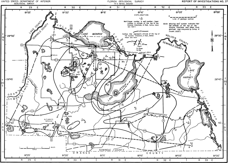
Description: This map shows the configuration and altitude of the top of the Eocene limestones in Seminole County, current to 1962. "The upper part of the Eocene Series in Seminole County consist of the Lake City Limestone, the Avon Park Limestone, and the Ocala Group. Figure 4 shows contours in altitude in feet below sea level of the top of the Eocene limestones in Seminole County. The amount of casing required to case a well to the uppermost limestone formation can be determined approximately from this map if the land-surface elevation is known. The upper surface of the Eocene Limestone ranges from 75 to about 190 feet below the land surface." — Jack T. Barraclough, U. S. Geological Survey, 1962
Place Names: Seminole, Orange County, Lake County, Volusia County, St. Johns River, Lake Monroe, Lake Jessup, Wekiva River, Econlockhatchee River, Geneva, Lake Harney, Chuluota, Oviedo, Fern Park, Altamonte Springs, Longwood, Sanford, Paola, Lake Mary, counties
ISO Topic Categories: boundaries, geoscientificInformation, transportation, inlandWaters
Keywords: Configuration and Altitudes of the Top Eocene Limestones, physical, political, transportation, hydrological, geological, county borders, roads, boundaries, geoscientificInformation, transportation, inlandWaters, Unknown,1962
Source: Jack T. Barraclough, U. S. Geological Survey, Ground-Water Resources of Seminole County, Florida (Tallahassee, FL: Florida Geological Survey, 1962)
Map Credit: Courtesy the University of South Florida Library |
|
