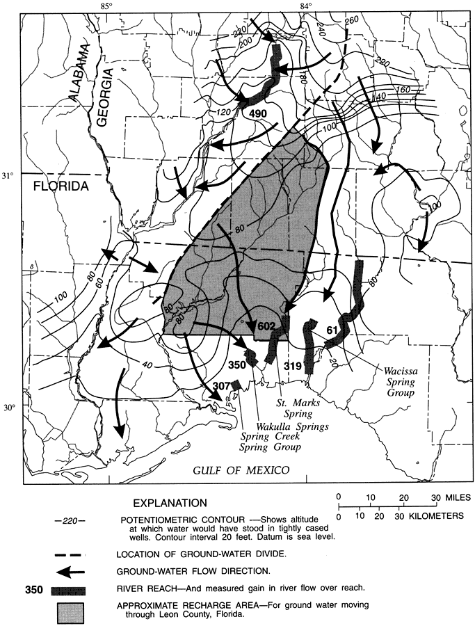
Description: This map from the U. S. Geological Survey Water Resources Investigation Report number 95-4296 shows the general flow direction of groundwater through Leon County. The map also shows net gain in river flow over reach during October and November, 1991, for Spring Creek, Wakulla Springs, St. Marks Spring, Wacissa Spring group, and the Aucilla River as a result of groundwater flow during the period. The map shows the potentiometric contours for the recharge area, which indicates the altitude related to sea level at which water would have stood in a tightly cased well. The groundwater divide is shown by a dark dashed line, indicating the approximate area where groundwater flows either westward toward the Flint River or southward to the large springs in and around Leon County. The location of this groundwater divide runs almost parallel to the Apalachicola Embayment-Gulf Trough feature. This feature has been described as a marine channel that once linked the Gulf of Mexico to the Atlantic Ocean during the early Tertiary, separating what we now know as Florida from the North American mainland.
Place Names: Leon, Tallahassee, Georgia, Gadsden County, Liberty County, Wakulla County, Franklin County, Jefferson County, Taylor County, Madison County, Calhoun County, Ochlockonee River, St. Marks River, Wacissa Springs, Wakulla Springs
ISO Topic Categories: boundaries, geoscientificInformation, inlandWaters
Keywords: Groundwater Flow Directions and Recharge Area for Leon County, physical, political, hydrological, khydrological, physical features, topographical, major political subdivisions, county borders, water table, drainage basins, boundaries, geoscientificInformation, inlandWaters, Unknown,October and November 1991
Source: Hal Davis, USGS Water Resources Investigations Report 95-4296 (Tallahassee, FL: U. S. Geological Survey, 1996) 24
Map Credit: Courtesy the University of South Florida Library |
|