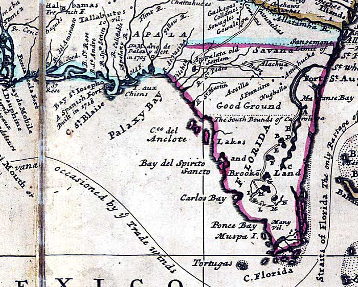
Description: A detail from the 1719 Moll World Map showing the Florida peninsula, coastline, major rivers including the St. Johns River, and settlements including St. Augustine. The full title of map is "A new map of the north parts of America claimed by France under ye names of Louisiana, Mississipi [i.e. Mississippi], Canada, and New France with ye adjoining territories of England and Spain : to Thomas Bromsall, esq., this map of Louisiana, Mississipi [i.e. Mississippi] & c. is most humbly dedicated, H. Moll, geographer / laid down according to the newest and most exact observations by H. Moll, geographer, 1720." This map shows the claimed territories of France outlined in blue, including Pensacola, St. Marks, and lands west of the present day Wacissa River, and Spain in red, which includes peninsular Florida north to the limit granted by King Charles II to the proprietors of Carolina in 1663. The map also describes a slave-hunting expedition in Florida from the St. Whanis River (St. Johns) inland: "Explanation of an Expedition in Florida neck, by Thirty-three Iamesee Indians Accompanyid bt Capt. T. Nairn. A. The place where the Indians leave their Canoes to go a Slave-Hunting, it is 6 days Rowing from St. Whanis Rivers Mouth. B. Large inland Lakes, some of them joined together. C. The Furthermost place where ye Indians have gone with Canoes. D. Place where they left their Canoes. E. The Path they took to go a Slave Catching. F. Cacema Town. G. Large Pond where was one house. H. Place where they Swam over a Deep River. I. The same River is here Brackish. K. Place where they took 29 Slaves. L. Here they took 6 Slaves. M. Here they took and Killed 33 Men at 2 a Clock ye same day a very Numerous body of Indians came against them, they being but 33 Men, yet put them presently to Flight; they having no Armes but Harpoos, made of Iron and Fish bones; they were all Painted. N. Fresh water Creek."The map shows the route of Spanish Galleons from Havana, Cuba to Spain through the Florida Straits.
Place Names: 1740-1759, Florida, St. Augustine, St. Augustin, Iamesee, Allawata, Palaxy Bay, Pensacola, Tortugas
ISO Topic Categories: inlandWaters, oceans, society
Keywords: Detail - A new map of the north parts of America claimed by France..., physical, political, historical, physical features, major political subdivisions, inlandWaters, oceans, society, Mercator, 1719
Source: Herman Moll, (London, : John Bowles, 1720)
Map Credit: Courtesy of the Geography and Map Division of the Library of Congress |
|