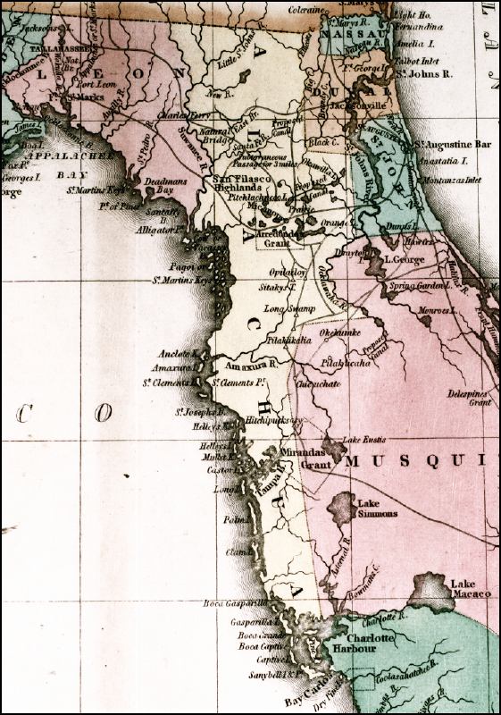
Description: This 1827 map shows major rivers, lakes, coastal features, settlements, and roads in Florida. There are six counties shown in this detail: Musquito, Alachua, St. Johns, Duval, Nassau, and Leon, which differs from the number found on current maps for the same area. Musquito County no longer exists, and Alachua County no longer extends from the Georgia State Line to Charlotte Harbor. The Arredondo and Mirandas land grants are shown, as well as proposed shipping canals. Lake Okeechobee is shown as Lake Macaco.
Place Names: 1820-1839, Tallahassee, Leon County, Alachua County, Nassau County, Duval County, St. Johns County, Musquito County, Saint Augustine, Jacksonville, Lake Macaco, Nassau, Charlotte Harbor
ISO Topic Categories: boundaries, inlandWaters, oceans, transportation
Keywords: Geographical, statistical, and historical map of Florida, physical, political, historical, transportation, physical features, major political subdivisions, county borders, roads, boundaries, inlandWaters, oceans, transportation, Unknown,1827
Source: Joseph Drayton, A complete historical, chronological, and geographical American atlas (Philadelphia, PA: Carey and Lea , 1827) Plate 37
Map Credit: Courtesy of the Special Collections Department, University of South Florida |
|