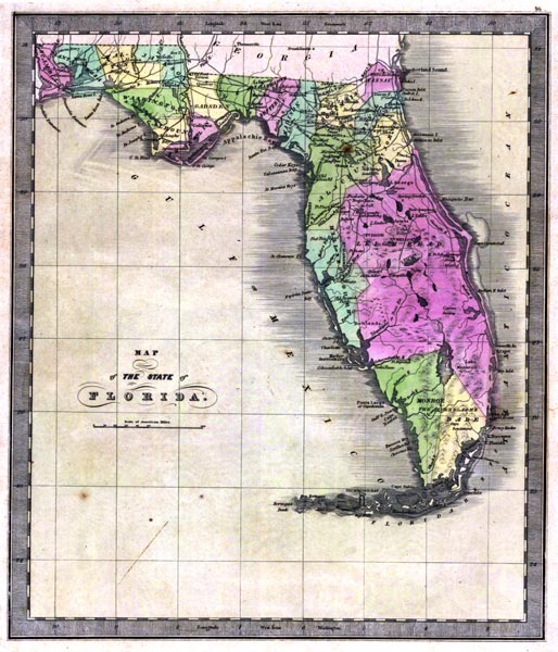
Description: This 1842 map of Florida shows roads, railroads, counties, forts, naval depots and other military installations, major towns, rivers, and lakes. Of interest are the counties of the time, including Leigh Read County, which was proposed but never passed in legislature. The two railroads shown on the map run between Tallehassee (Tallahassee) and St. Marks, and between St. Josephs (St. Joe) and Iola. Longitude is shown from Greenwich at the top of the map, and Washington at the bottom of the map. The map scale is in &quoe;American Miles."
Place Names: 1840-1859, Jacksonville, Fernandina, Saint Augustine, Tallehassee, Tallahassee, Cape Canaveral, Tampa Bay, Fort Brooke, Lake Mayacoo, Lake Okeechobee, Key West, Sandwich Gulf, Card Sound, Charlotte Harbor, Cedar Keys, St. Marks, Pensacola
ISO Topic Categories: boundaries, inlandWaters, oceans, society
Keywords: Map of the State of Florida, physical, political, transportation, historical, physical features, major political subdivisions, county borders, roads, boundaries, inlandWaters, oceans, society, Unknown,1842
Source: Jeremiah Greenleaf, A New Universal Atlas (Brattleboro, VT: , 1842) 56
Map Credit: Courtesy the private collection of Roy Winkelman |
|