mapsExploring Florida
 FL Maps > Region > 1840-1859 > Detail - Johnson's new railroad & county copper plate map of the southern states from the latest and best information, 1859
Site Map 

Detail - Johnson's new railroad & county copper plate map of the southern states from the latest and best information, 1859

Detail - Johnson's new railroad & county copper plate map of the southern states from the latest and best information


Title: Detail - Johnson's new railroad & county copper plate map of the southern states from the latest and best information
Projection: Unknown
Source Bounding Coordinates:
W: E: N: S:

Main Map Page
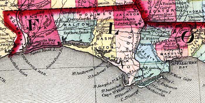
Description: This detail from the Johnson's 1859 railroad map shows counties, roads, railroads, major rivers, and towns in the Florida panhandle region from Jefferson County west to Escambia County.
Place Names: 1840-1859, Pensacola, Tallahassee, St. Marks, Appalachee Bay, Cape San Blas, Appalachicola River
ISO Topic Categories: boundaries, inlandWaters, oceans, transportation
Keywords: Detail - Johnson's new railroad & county copper plate map of the southern states from the latest and best information, physical, political, transportation, physical features, major political subdivisions, county borders, roads, railroads, boundaries, inlandWaters, oceans, transportation, Unknown,1859
Source: Johnson & Browning, (, : Johnson & Browning, 1859)
Map Credit: Courtesy of the Geography and Map Division of the Library of Congress
SearchLicensePDF HelpGIS Help Google Earth Help Zoomify Help

 FL Maps > Region > 1840-1859 > Detail - Johnson's new railroad & county copper plate map of the southern states from the latest and best information, 1859
Site Map