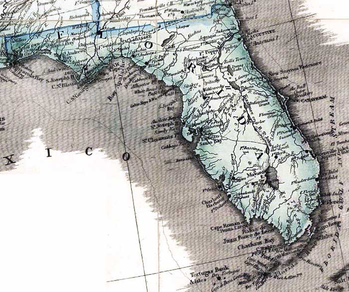
Description: This detail from the 1861 map "Wyld's military map of the United States, the northern states, and the southern confederate states: with the forts, harbours, arsenals, and military positions" shows Florida as a slave state. Several Civil War era Army forts are shown, as well as roads, railroads, major towns, and a proposed canal route from Fernandina to Apalachicola. Lakes and rivers are shown, with certain discrepancies such as the location of Mayaco Lake or Lake Okeechobee, and the fact that it feeds the St. Johns River.
Place Names: 1860-1879, Pensacola, Tallahassee, Ft. Pickens, Ft. McRae, Ft. Apalachicola, Ft. Scott Arsenal, Ft. Andrews, Ft. Frank, Ft. Armstrong, Ft. Harrison, Ft. Brooke, Ft. Clinch, Saint Augustine, Ft. Poppa, Ft. Anno, Ft. Lloyd, Ft. Capron, Cape Canaveral, Ft. Pierce, Ft. Jupiter, Ft. Lauderdale, Ft. Luderdale, Ft. Thompson, Ft. Taylor, Dry Tortugas, Ft. Jefferson, Ft. Myers, Ft. Dulaney, Ft. Casey, Mayaco Lake, Lake Okeechobee,
ISO Topic Categories: boundaries, inlandWaters, oceans, society, transportation
Keywords: Detail - Wyld's military map of the United States..., physical, political, transportation, historical, physical features, major political subdivisions, roads, railroads, Civil War, boundaries, inlandWaters, oceans, society, transportation, Unknown,1861
Source: James Wyld, (London, : James Wyld, 1861)
Map Credit: Courtesy of the Geography and Map Division of the Library of Congress |
|