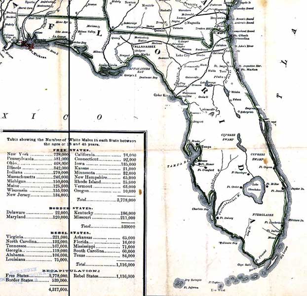
Description: This detail is from Russell's 1862 historical war map, showing major rivers, railroads, towns, and military forts in Florida. The map also has Census data from 1860, showing Florida with a population of 16,000 White males between the ages of 18 and 45 years, a non-slave population of 92,741 and a Slave population of 61,753. Florida, according to the 1860 Census, was the least populated Rebel State.
Place Names: 1860-1879, Pensacola, Ft. McRae, Ft. Pickens, Quincy, Tallahassee, St. Marks, Ft. Clinch, Fernandina, Jacksonville, Saint Augustine, Ft. Marion, Cedar Keys, Ft. Bassinger, Ft. Capron, Ft. Brooke, Tampa, Manatee, Ft. Hamer, Ft. Crawford, Ft. Center, Ft. Jupiter, Ft. Lauderdale, Ft. Dallas, Miami, Ft. Dulany, Key West, Ft. Taylor, Ft. Jefferson
ISO Topic Categories: boundaries, inlandWaters, oceans, society, transportation
Keywords: Detail - The historical war map, physical, political, statistical, historical, transportation, physical features, major political subdivisions, population, railroads, Civil War, boundaries, inlandWaters, oceans, society, transportation, Unknown,1862
Source: Benjamin B. Russell, The historical war map (Buffalo, NY: Asher & Co. , 1862)
Map Credit: Courtesy of the Geography and Map Division of the Library of Congress |
|