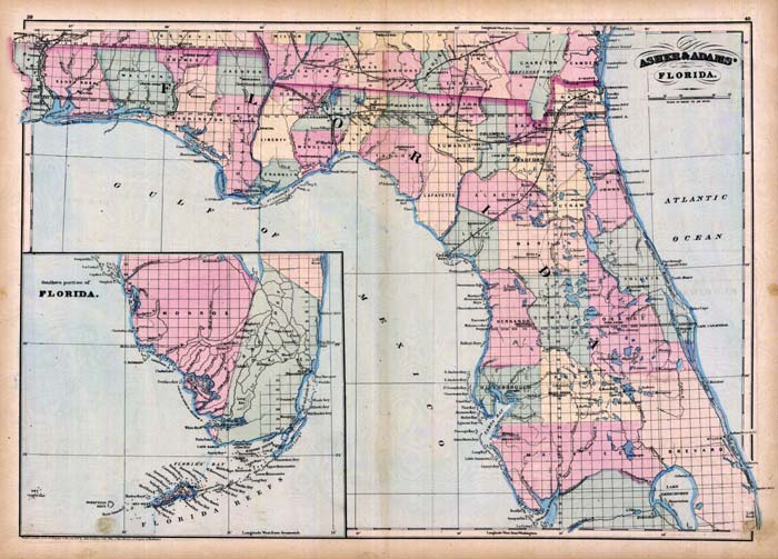
Description: This 1871 map of Florida shows county lines and county seats current to the period, major towns and cities, and railroad routes and stations. The Township and Range survey grid is shown extending from the Tallahassee Base Line and the Tallahassee Meridian (established in 1824) and the fact that much of the Everglades and the Forbes Purchase or Forbes Grant in northern Florida were not surveyed in 1871. Although the Everglades were not surveyed using the Township Range grid, many "island" features are shown in the glades, including Prophets, Cabbage, Sam Jones, Bear, Lulaxia, Chikiki, Capabula, and Burke islands, and Long Key. Several cities and towns have subtitles, including Miami or Biscayne P. O., Brooksville or Pierceville in Hernando County, Rosehead or Perry in Taylor County, Ocala or Marion Center in Marion County, McIntosh or New Troy in Lafayette County, and Peace Creek or Bartow in Polk County. Digitization provided by the USF Libraries Digitization Center.
Place Names: 1860-1879, Miami, Biscayne P.O., Amelia Island, Anastasia Island, Apalachicola, Cape Canaveral, Cedar Key, Charlotte Harbor, Jacksonville, Gainesville, Saint Augustine, St. Marks, Pensacola, Bayport, Tampa, Quincy, Orlando, Manatee, Key West, Lake Okeechobee
ISO Topic Categories: boundaries, inlandWaters, oceans, transportation
Keywords: Asher & Adams’ Florida, physical, political, transportation, physical features, major political subdivisions, county borders, railroads, boundaries, inlandWaters, oceans, transportation, Unknown,1871
Source: Asher & Adams, Asher & Adams’ new commercial, topographical, and statistical atlas and gazetteer of the United States (New York, NY: Asher & Adams, 1871)
Map Credit: Courtesy of the private collection of Roy Winkelman |
|