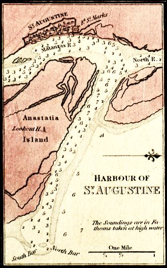
Description: Digitization provided by the USF Libraries Digitization Center. Rare Maps. This is a map of St. Augustine and its harbor, circa 1850. This map shows water depths measured in fathoms, locations, physical features and inland waters. Also shown is the grid of the main township of Saint Augustine. North is to the right.
Place Names: St. Johns, Saint Augustine, St. Augustine, Atlantic Ocean, St. Marks River, Matanzas River, Anastasia Island, Castillo de San Marcos, Matanzas, Fort Saint Marks,
ISO Topic Categories: inlandWaters, location
Keywords: Saint Augustine, physical, hydrological, physical features, water depths, inlandWaters, location, Unknown,1850
Source: , (, : , 1850)
Map Credit: Courtesy of the Special Collections Department, University of South Florida. |
|