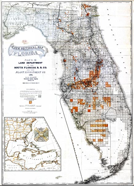
Description: This map shows county lines and county seats current to the period, major towns and cities, and railroad routes and stations. The Township and Range survey grid is shown extending from the Tallahassee Base Line and the Tallahassee Meridian. The Townships are subdivided into sections, and those sections offered for sale by the land department of the South Florida R.R. Company are shown in orange. Map scale is 1:633,600. The map also shows the route of the Plant Steamship Line from Port Tampa to Key West and Havana carrying U.S. Mails. The inset map shows the geographical position of Florida with connecting railroads and steamship lines "for commerce with other states, and the countries south and east of Gulf of Mexico."
Place Names: 1880-1899, Jacksonville, Saint Augustine, Cape Canaveral, Palatka, Sanford, Orlando, Kissimmee, Bartow, Tampa, Plant City, St Petersburg, Live Oak, Gainesville, Key West, Havana
ISO Topic Categories: boundaries, inlandWaters, oceans, transportation
Keywords: A new sectional map of Florida, physical, political, transportation, physical features, major political subdivisions, county borders, local jurisdictions, railroads, boundaries, inlandWaters, oceans, transportation, Unknown,1888
Source: D. H. Elliott, (Sanford, FL: South Florida R. R. Co. and the Plant Investment Co, 1888)
Map Credit: Courtesy the private collection of Roy Winkelman |
|