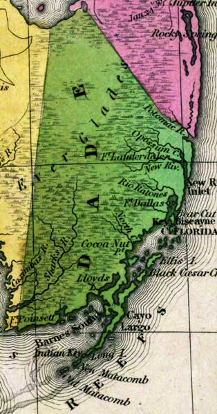
Description: This detail of a map from the Tanner's Universal Atlas shows towns, forts, roads, canals, major rivers and lakes in Dade County. In 1839, the Upper Keys were included in Dade County. This includes Barnes Sound. Notable indications on the detail are Cayo Largo, Fort Lauderdale, the Potomac River, and Fort Dallas. There are references to forts, battlefields, and routes used by the Army during the Seminole War. The Longitude is from the Washington Prime Meridian.
Place Names: Dade, Potomac River, Opossum Creek, Fort Lauderdale, Rio Ratones, Fort Dallas, New River Inlet, Biscayne, North Creek, Sharks River, Cayo Largo, Barnes Sound, Ellis Island, Cocoa Nut Point, Indian Key, Matacomb, Everglades,
ISO Topic Categories: boundaries, inlandWaters, oceans, society, transportation
Keywords: Detail - Florida, physical, political, transportation, historical, physical features, county borders, roads, other military, boundaries, inlandWaters, oceans, society, transportation, Unknown,1839
Source: Henry Schenck Tanner, Tanner's Universal Atlas (Philadelphia, PA: Carey & Hart, 1839) 21
Map Credit: Courtesy the private collection of Roy Winkelman |
|