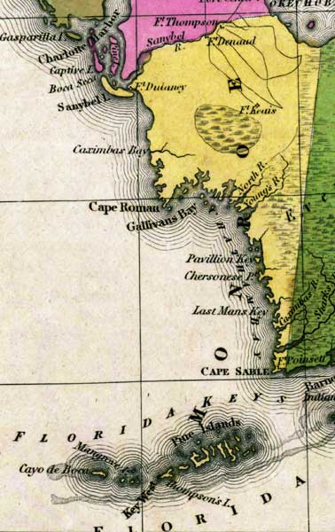
Description: This detail of a map from the Tanner's Universal Atlas shows towns, forts, roads, canals, major rivers and lakes in Monroe County. This detail shows many forts including Fort Denaud, Fort Dulaney, and Fort Keais. Along the coastline, there are several defined features such as Cape Roman, Gallivans Bay, Chatham Bay, and the Lower Florida Keys. There are references to forts, battlefields, and routes used by the Army during the Seminole War. The Longitude is from the Washington Prime Meridian.
Place Names: Monroe, Everglades, Fort Denaud, Fort Dulaney, Fort Keais, Caximbas Bay, North River, Young's River, Cape Roman, Gallivans Bay, Pavillion Key, Chersonese Point, Last Mans Key, Chatham Bay, Cape Sable, Pine Islands, Key West, Mangrove Island, Cayo de Boca, Lake Okeechobee
ISO Topic Categories: boundaries, inlandWaters, oceans, society, transportation
Keywords: Detail - Florida, physical, political, transportation, historical, physical features, county borders, roads, other military, boundaries, inlandWaters, oceans, society, transportation, Unknown,1839
Source: Henry Schenck Tanner, Tanner's Universal Atlas (Philadelphia, PA: Carey & Hart, 1839) 21
Map Credit: Courtesy the private collection of Roy Winkelman |
|