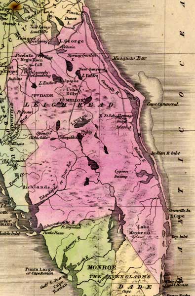
Description: This detail of a 1842 map of Florida shows roads, railroads, counties, forts, naval depots and other military installations, major towns, rivers, and lakes for Leigh Read County, which was proposed but never passed in legislature, so is actually Mosquito County. Longitude is shown from Greenwich at the top of the map, and Washington at the bottom of the map. The map scale is in &quoe;American Miles."
Place Names: Leigh Read , Lake George, Volusia, Spring Garden Lake, Musquito Bar, Greenville River, Fort Mellon, Lake Eustace, Picolata, Silver Spring, Fort Dade, New Smyrna, Lake Peyton, Fort Foster, Cape Cannaveral, Cape Canaveral, Flemings, Indian River, Tokopalika Lake, Peace River, Cypress Swamp, Lake Mayacoo, Cohoosahatchee River,
ISO Topic Categories: boundaries, inlandWaters, oceans, society
Keywords: Detail - Leigh Read County, physical, political, transportation, historical, physical features, major political subdivisions, county borders, roads, boundaries, inlandWaters, oceans, society, Unknown,1842
Source: Jeremiah Greenleaf, A New Universal Atlas (Brattleboro, VT: , 1842) 56
Map Credit: Courtesy the private collection of Roy Winkelman |
|