Maps Site map
  FL Maps > State > 1700-1719
Site Map  

  Record   1   to   6  of   6

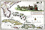
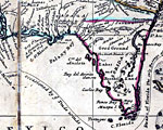
De vaste kust van Chicora tussen Florida en Virginie, 1706
Digitization provided by the USF Libraries Digitization Center. Rare Maps Collection: Notes from USF Library: Relief shown pictorially/ In Dutch and French. Scale measurement derived from scale bar (1 in. = 50 Milliaria Germanica communia)./ "Terre ...

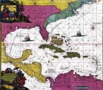
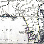
Indiarum Occidentalism tractus littorales cum insulis Caribicis Pascaert van Westindien ende Caribise eylanden, 1715
Digitization provided by the USF Libraries Digitization Center. Rare Maps Collection: Notes from USF Library:...

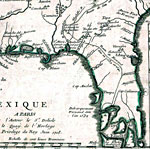
Detail - Carte de la Louisiane et du cours du Mississipi, 1718
This detail is from the 1718 DeLisle map titled "Carte de la Louisiane et du cours du Mississipi [i.e. Mississippi]: dressée sur un grand nombre de mémoires entrautres sur ceux de Mr. le Maire / par Guillaume Del'isle del Academie R'le. des Scie...

Detail - A new & correct map of the whole World, 1719
A detail from the 1719 Moll World Map showing the Florida peninsula, coastline, major rivers including the St. Johns River, and settlements including St. Augustine....

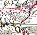
Detail - A new map of the north parts of America claimed by France..., 1719
A detail from the 1719 Moll World Map showing the Florida peninsula, coastline, major rivers including the St. Johns River, and settlements including St. Augustine. The full title of map is "A new map of the north parts of America claimed by Fra...

Detail - A map of Louisiana and of the river Mississipi, 1719
This detail is from the 1719 map by John Senex "A map of Louisiana and of the river Mississipi [i.e. Mississippi] : this map of the Mississipi [i.e. Mississippi] is most humbly inscribed to William Law of Lanreston, esq. / by Iohn Senex." S...


  FL Maps > State > 1700-1719
Site Map  

Maps ETC is a part of the Educational Technology Clearinghouse
Produced by the Florida Center for Instructional Technology © 2007
College of Education , University of South Florida