| 
|
1876,
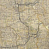
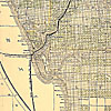
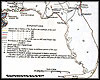
Texas and Pacific Railway and its connections. |
 |
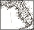
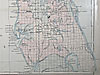
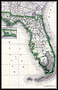
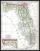
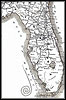
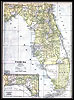
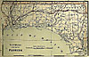
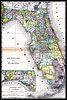
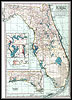
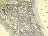
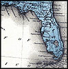
An
1877 map of Florida.  |
 |
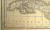
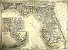
Detailed
view of the Florida panhandle from an 1877 map of Florida. |
 |
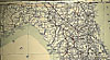
Detailed
view of north Florida from an 1877 map of Florida. |
 |
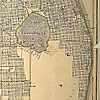
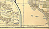
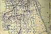
Detailed
view of central Florida from an 1877 map of Florida. |
 |
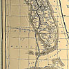
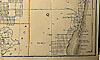
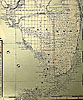
Detailed
view of south Florida from an 1877 map of Florida. |
|
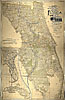
1877, Map of Florida that was, "Entered according to Act of Congress
in the year 1877 by Asher and Adams..." |
|
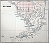
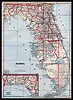
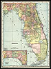
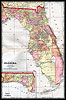
1880, Map of Florida. |
|
1880, Rand, McNally & Company map.
|
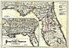 |
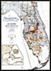
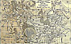
Maps showing the Florida Transit and Peninsula Rail
Road and its connections from 1882. |
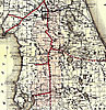 |
Detailed
view of Florida Transit map displaying fifteen mile land grant limits
surrounding the track. |
| 
|
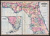
1883,
Phillips and Hunt map. |
|
1886, Geo.F.Cram Engraver & Publisher map. |
|
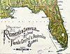
1888, A new sectional map of Florida issued by the land department
of the South Florida R. R Co. and the Plant Investment Co., Sanford,
Florida |
|
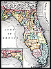
1888, Rand, McNally & Company map. |
 |
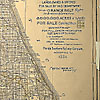
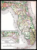
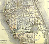
An
1888 map of eastern and southeastern Florida showing the lands offered
for sale by the Florida Southern Railway Company. |
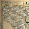 |
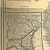
View
of Jefferson, Madison, Taylor, Hamilton, Suwannee, and Lafayette counties
from an 1888 map of eastern and southeastern Florida showing the lands
offered for sale by the Florida Southern Railway Company. |
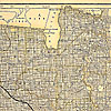 |
Detailed
view of Columbia, Bradford, Nassau, Duval, Clay, and surrounding counties
from an 1888 map of eastern and southeastern Florida showing the lands
offered for sale by the Florida Southern Railway Company. |
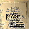 |
Detailed
view of the map title from an 1888 map of eastern and southeastern Florida
showing the lands offered for sale by the Florida Southern Railway Company. |
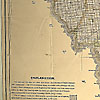 |
Detailed
view of parts of Lafayette and Levy counties from an 1888 map of eastern
and southeastern Florida showing the lands offered for sale by the Florida
Southern Railway Company. |
 |
Detailed
view of Marion, Citrus, and parts of surrounding counties from an 1888
map of eastern and southeastern Florida showing the lands offered for
sale by the Florida Southern Railway Company. |
 |
Detailed
view of parts of Volusia and surrounding counties from an 1888 map of
eastern and southeastern Florida showing the lands offered for sale by
the Florida Southern Railway Company. |
 |
Detailed
view of an insert map of Georgia showing rail routes into Florida from
an 1888 map of eastern and southeastern Florida showing the lands offered
for sale by the Florida Southern Railway Company. |
 |
Detailed
view of Pasco, Hillsborough, Polk, and parts of surrounding counties from
an 1888 map of eastern and southeastern Florida showing the lands offered
for sale by the Florida Southern Railway Company. |
 |
Detailed
view of parts of Osceola, Brevard, and surrounding counties from an 1888
map of eastern and southeastern Florida showing the lands offered for
sale by the Florida Southern Railway Company. |
 |
Detailed
view of an inset map of Florida showing rail routes from an 1888 map of
eastern and southeastern Florida showing the lands offered for sale by
the Florida Southern Railway Company. |
 |
Detailed
view of parts of DeSoto and Lee counties from an 1888 map of eastern and
southeastern Florida showing the lands offered for sale by the Florida
Southern Railway Company. |
 |
Detailed
view of Lake Okeechhhobee, and parts of Dade and surrounding counties
from an 1888 map of eastern and southeastern Florida showing the lands
offered for sale by the Florida Southern Railway Company. |
 |
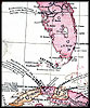
Detailed
view of Cuba from an 1888 map of eastern and southeastern Florida showing
the lands offered for sale by the Florida Southern Railway Company. |
 |
Detailed
view of Cuba and part of Southwest Florida from an 1888 map of eastern
and southeastern Florida showing the lands offered for sale by the Florida
Southern Railway Company. |
 |
Detailed
view of parts of Monroe and Dade counties from an 1888 map of eastern
and southeastern Florida showing the lands offered for sale by the Florida
Southern Railway Company. |
| 
|
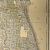
1888,
New and correct map of the Chicago, Kansas & Nebraska Ry. Rock Island
Route. Published by Buffalo. |
| 
|
1889,
Historical sketch of the war for the Union showing the lines of demarcation,
important movements and battles in each year from 1861 to the close
of the war in 1865. |
|
1890, George F. Cram map. |
|
1890, Rand, McNally & Company map. |
 |
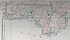
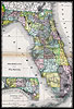
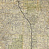
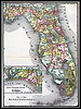
Map
of Florida created during the 1890s that indicates train routes. |
 |
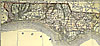
Detailed
view of the Florida panhandle from a map of Florida created during the
1890s that indicates train routes. |
 |
Detailed
view of north Florida from a map of Florida created during the 1890s that
indicates train routes. |
 |
Detailed
view of central Florida from a map of Florida created during the 1890s
that indicates train routes. |
 |
Detailed
view of south Florida from a map of Florida created during the 1890s that
indicates train routes. |
| 
|
1892,
Rand, McNally & Company map. |
 |
1893,
George F. Cram map. |
 |
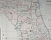
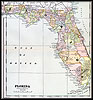
Map
of Florida railroads from 1893. |
|
1894, Rand, McNally & Company map. |
|
1897, The Century Atlas. |
 |
1898,
John W. Iliff and Company map. |
 |
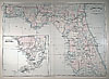
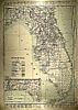
An
atlas map of Florida from 1898. |
 |
Detailed
view of the Florida panhandle from an atlas map of Florida created during
the mid-18th century. |
 |
Detailed
view of the North Florida from an atlas map of Florida created during
the mid-18th century. |
 |
Detailed
view of Lake, Orange, and Volusia counties from an atlas map of Florida
created during the mid-18th century. |
 |
Detailed
view of central and south Florida from an atlas map of Florida created
during the mid-18th century. |
 |
Detailed
view of the Everglades and the Keys from an atlas map of Florida created
during the mid-18th century. |
| 
|
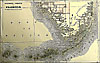
1898,
The Evening Post map of the West Indies. |
|
1899, CRAM map. |
| 
|
1899,
Goff's historical map of the Spanish-American War in the West Indies. |