|
|
|
| FL Maps > County > Leigh Read |
Click on a thumbnail image to view a full size version of that map.
Leigh Read was never an official county of Florida. There was an attempt in 1842 to rename Mosquito County to Leigh Read County. It would have been named in honor of the former legislator. Although the bill honoring Read passed the legislature, a clerk kept the bill from reaching the governor's desk. Therefore, it never became official, but the name Leigh Read can be found in several documents of the time.
For other maps of this area, visit the Mosquito County and Orange County map galleries.
|
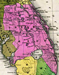
Detail- Leigh Read County,
1839 |
|
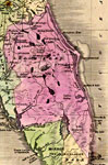
Detail - Leigh Read County,
1842 |
| FL Maps > County > Leigh Read |
Maps ETC
is a part of the
Educational Technology Clearinghouse
Produced by the
Florida Center for Instructional Technology
© 2007
College of Education
,
University of South Florida