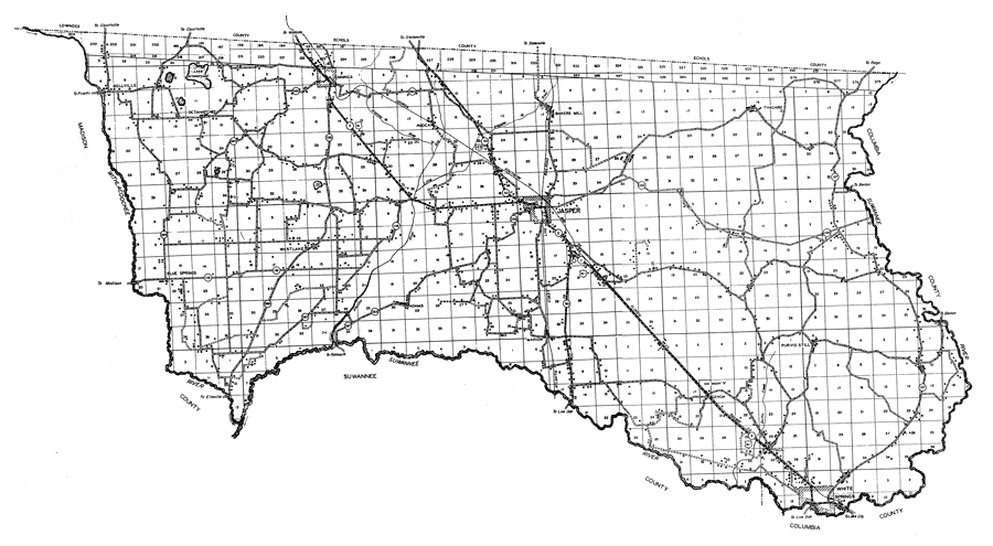
Description: This is a detailed map of the county of Hamilton in the state of Florida. Section Township Range (STR) is shown. This map shows all of the main cities, state roads , US Highways, bridge highways, drawbridge highways, federal aided highway, railroads, inland waters, forest service lookout stations, canals, ferries, corporate lines, county boundary, county seat, tourist camps, post offices, monuments, turpentine still, cemeteries, churches, farm units, dwellings other than farms, tenant houses, businesses, townhalls, hotels, schools, hospitals and factories. Key to Florida Highway maps.
Place Names: Hamilton, Octahatchee, Jennings, Westlake, Blue Springs, Lake Octahatchee, Avoca, Jasper, Bakers Mill, White Springs, Marion, Bellville, Adams, Suwannee River
ISO Topic Categories: boundaries, inlandWaters, location, transportation
Keywords: Hamilton, physical, political, transportation, physical features, major political subdivisions, county borders, local jurisdictions, roads, railroads, boundaries, inlandWaters, location, transportation, Unknown,1936
Source: , Florida State Road Department (, : , 1936)
Map Credit: Courtesy the private collection of Roy Winkelman. |
|