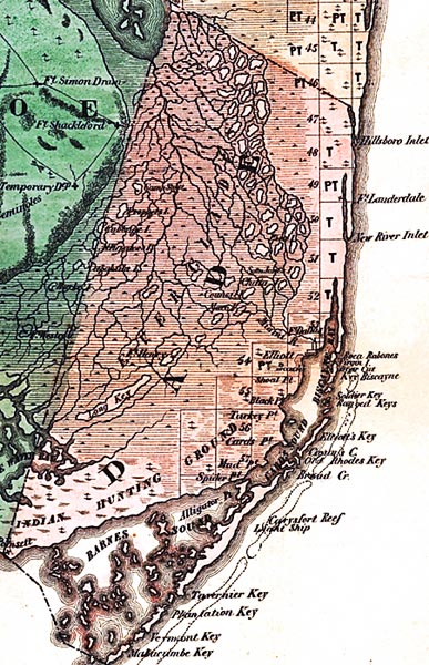
Description: This detail of a map from the annual report of the Surveyor General in 1856 shows Dade County. Drainage, cities and towns, roads, trails, and location of railroad lines are shown in great detail. The major feature of detail is the Everglades. Other points of interest include Hillboro Inlet, Fort Lauderdale, Barnes Sound, and Biscayne Bay.
Place Names: Dade, Hillsboro Inlet, Fort Lauderdale, New River Inlet, Fort Dallas, Boca Rabones, Key Biscayne, Soldier Key, Elliot's Key, Tavernier Key, Plantation Key, Vermont Key, Barnes Sound, Alligator Point, Indian Hunting Ground, Long Key, Spider Point, Mud Point, Turkey Point, Biscayne Bay,
ISO Topic Categories: boundaries, inlandWaters, oceans, society, transportation
Keywords: Dade County, physical, political, transportation, physical features, major political subdivisions, county borders, local jurisdictions, roads, railroads, boundaries, inlandWaters, oceans, society, transportation, Unknown,1856
Source: Columbus Drew, (Jacksonville, FL: Columbus Drew, 1856)
Map Credit: Courtesy of the Geography and Map Division of the Library of Congress |
|