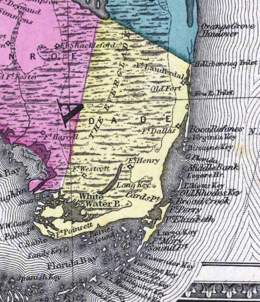
Description: This detail of a 1873 map of Florida, Georgia, and South Carolina shows an in color portrait of county lines of the period, Florida railroad routes, forts, and outlines major waterways for Dade County. The major water features of the detail are White Water Bay and Barnes Sound. Other features include Fort Lauderdale, Fort Dallas, and Cape Cable.
Place Names: Dade, Everglades, Fort Lauderdale, Old Fort, Fort Dallas, Fort Henry, Fort Westcott, Long Kay, Cards Point, White Water Bay, Fort Poinsett, Cape Sable, Florida Bay, Barnes Sound, New River Inlet, Boca Raton, Virginia, Biscayne, Middle Bank, Elliotts Key, Broad Creek, Point Perry, Point Elizabeth, Largo Key, Key Largo, Poinr Mary, Sound Pont, Tavernier Key, Vermont Key, Beacon Key, Matacombe Key, Alligator Key, Long Key, Spanish Key,
ISO Topic Categories: boundaries, inlandWaters, oceans, transportation
Keywords: Dade County, physical, political, transportation, physical features, major political subdivisions, county borders, railroads, boundaries, inlandWaters, oceans, transportation, Unknown,1873
Source: Simon J. Martenet, New topographical atlas of the State of Ohio (, : Stedman, Brown & Lyon/H.H. Lloyd and Co., 1873) 89
Map Credit: Courtesy of the private collection of Roy Winkelman |
|