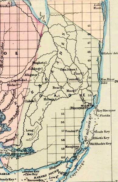
Description: This 1871 detail of Florida shows county lines and county seats current to the period, major towns and cities, and railroad routes and stations for Dade County. The major water features of this detail are Key Biscayne Bay and Barnes Sound. Other locations include Miami and Key Largo. Digitization provided by the USF Libraries Digitization Center.
Place Names: Dade, Hillsboro Inlet, New River Inlet, Key Biscayne, Cape Florida, Miami, Miami River, Prophets Island, Cabbage Island, Alligator Island, Sam Jones Island, Pine Island, Council Island, Bear Island, Maco Island, Eulasia Island, Chikiki Island, Long Key, Key Bisacayne Bay, Sands Key, Elliots Key, Old Rhodes Key, Cayo Largo, Barnes Sound, White Water Bay, Cape Sable, Sandy Key, Oyster Key, Clive Key, Raccoon Keys, Rabbit Key, Key Largo
ISO Topic Categories: boundaries, inlandWaters, oceans, transportation
Keywords: Dade County, physical, political, transportation, physical features, major political subdivisions, county borders, railroads, boundaries, inlandWaters, oceans, transportation, Unknown,1871
Source: Asher & Adams, Asher & Adams' new commercial, topographical, and statistical atlas and gazetteer of the United States (New York, NY: Asher & Adams, 1871)
Map Credit: Courtesy of the private collection of Roy Winkelman |
|