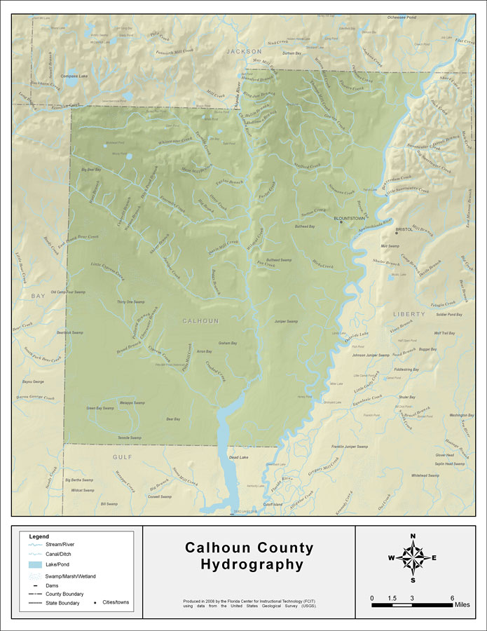
Description: This map was created by FCIT and shows the waterways of Calhoun County. All major rivers, streams, creeks, lakes, and swamps are labeled. This map features May Mill Creek, Hansford Branch, Ring Jaw Branch, Hollis Branch, Holliman Branch, Boardhead Branch, Farley Creek, Taylor Branch, Otter Creek, Simmons Creek, Stafford Creek, Sutton Creek, Thomas Mill Creek, Graves Creek, Wilson Mill Creek, Flowers Creek, Ocheesee Creek, Johnson Creek, The Bayou, Big Brook, Davis Mill Creek, Boogy Branch, Chipola River, Ammonia River Sand Slough, Hicks Creek, Apalachicola River, Hogpen Branch, Wildcat Creek, Fox Creek, Dead Lake, Pitts Mill Creek, Woods Branch, Crooked Creek, Cypress Creek, Broad Branch, Pole Branch, Clearwater Branch, Sandy Creek, Little Cypress Creek, East Prong Bear Creek, Bailey Branch, Jumper Creek, Watson Branch, Centerfit Branch, Huey Branch, Palmetto Branch, Panther Branch, Fourmile Creek, White Water Creek, Tenmile Creek, Econfina Creek, and Mayo Mill Branch.
Place Names: Calhoun, May Mill Creek, Hansford Branch, Ring Jaw Branch, Hollis Branch, Holliman Branch, Boardhead Branch, Farley Creek, Taylor Branch, Otter Creek, Simmons Creek, Stafford Creek, Sutton Creek, Thomas Mill Creek, Graves Creek, Wilson Mill Creek, Flowers Creek, Ocheesee Creek, Johnson Creek, The Bayou, Big Brook, Davis Mill Creek, Boogy Branch, Chipola River, Ammonia River Sand Slough, Hicks Creek, Apalachicola River, Hogpen Branch, Wildcat Creek, Fox Creek, Dead Lake, Pitts Mill Creek, Woods Branch, Crooked Creek, Cypress Creek, Broad Branch, Pole Branch, Clearwater Branch, Sandy Creek, Little Cypress Creek, East Prong Bear Creek, Bailey Branch, Jumper Creek, Watson Branch, Centerfit Branch, Huey Branch, Palmetto Branch, Panther Branch, Fourmile Creek, White Water Creek, Tenmile Creek, Econfina Creek, Mayo Mill Branch, Blountstown
ISO Topic Categories: boundaries, inlandWaters
Keywords: Florida Waterways: Calhoun County , political, physical, kriversandstreams, physical features, county borders, photograph in shape of map, photo, Florida mapboundaries, inlandWaters, 2008
Source: Florida Center for Instructional Technology, (Tampa, FL: University of South Florida, 2008)
Map Credit: Courtesy of the Florida Center for Instructional Technology |
|