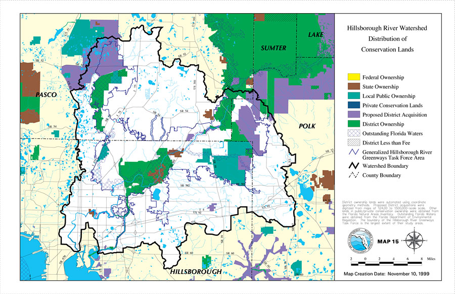
Description: This is a map from the Southwest Florida Watershed Management District or SWFWMD of the Hillsborough River watershed distribution of conservation lands, created on November 10, 1999. The following ownership classifications are shown by color: Federal Ownership (yellow), State Ownership (brown), Local Government Ownership (green), Private Conservation Lands (dark blue), Proposed District Acquisition (purple), District Ownership (bright green), and Less Than Fee (dashes). Less Than Fee means that someone has ownership, but with restricted rights because it is also conservation land. It also shows outstanding water (blue crosshatch), the Watershed Management boundary shown by the thick black line, US/State roads, inland water and county boundaries. "District ownership lands were automated using coordinate geometry methods. Proposed District acquisitions were digitized from maps of 1:24,000 to 1:500,000 scale. Other lands in public/private conservation ownership were obtained from the Florida Natural Areas Inventory. Outstanding Florida Waters were obtained from the Florida Department of Environmental Regulation. The boundary of the Hillsborough River Greenways Task Force is the largest extent of their study areas." —Southwest Florida Watershed Management District
Place Names: 1950-1999, Hillsborough River, �Hillsborough, �Polk, �Pasco, �Sumter, �Lake
ISO Topic Categories: boundaries, �inlandWaters, �transportation, �geoscientificInformation
Keywords: Hillsborough River Watershed Distribution of Conservation Lands- Map 15, physical, �political, �transportation, �hydrological, �watershed, �kwatershed, physical features, county borders, roads, boundaries, �inlandWaters, �transportation, �geoscientificInformation, Unknown,November 10, 1999
Source: Southwest Florida Water Management District, Hillsborough River Comprehensive Watershed Management Plan Atlas (Brooksville, FL: Southwest Florida Water Management District, 2000)
Map Credit: Courtesy of the Southwest Florida Water Management District |
|