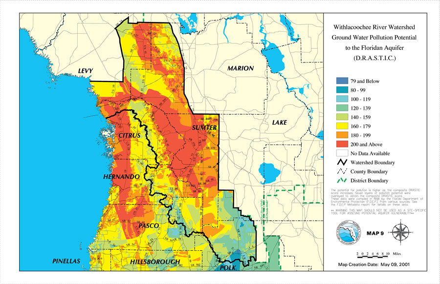
Description: This is a map from the Southwest Florida Watershed Management District or SWFWMD of the Withlacoochee River ground water pollution potential to the Floridian aquifer created on May 9, 2001. The pollution potential is shown with a composite DRASTIC score from least to greatest by color; Dark blue is the least and red is the most. It also shows the Watershed Management boundary shown by the thick black line, district boundary (green dashed line), US/State roads, inland water and county boundaries. "The potential for pollution is higher as the composite DRASTIC score increases. Seven layers of pollution potential were overlayed to obtain the composite DRASTIC score. These data were compiled in 1998 by the Florida Department of Environmental Protection (F.D.E.P.) from various sources. See the F.D.E.P. Metadata report for details on these data. **Warning. This map should not be used as a site-specific tool for assessing potential aquifer vulnerability.**" —Southwest Florida Watershed Management District
Place Names: 2000-, counties, �Marion, �Lake, �Sumter, �Citrus, �Hernando, �Levy, �Pasco, �Pinellas, �Hillsborough, �Polk
ISO Topic Categories: boundaries, �geoscientificInformation, �inlandWaters, �transportation
Keywords: Withlacoochee River Watershed Ground Water Pollution Potential�to the Floridan Aquifer (D.R.A.S.T.I.C.), physical, �political, �transportation, �hydrological, �watershed, �kwatershed, physical features, county borders, roads, boundaries, �geoscientificInformation, �inlandWaters, �transportation, Unknown,May 9, 2001
Source: Southwest Florida Water Management District, Withlacoochee River Comprehensive Watershed Management Plan Atlas (Brooksville, FL: Southwest Florida Water Management District, 2001)
Map Credit: Courtesy of the Southwest Florida Water Management District |
|