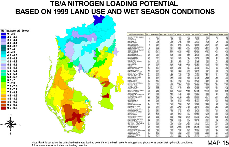
Description: This is a map from the Southwest Florida Watershed Management District or SWFWMD of the Tampa Bay/Anclote River watershed nitrogen loading potential based on 1999 land use and wet conditions, created in 2001. This map shows the loading potential by color in lbs/acre-yr starting with 0 (dark blue) going up to 9.5-9.8 (red). There is also a table to the right of the map showing each drainage basin, its rank, how many acres it covers, runoff volume, and the loading potential for 6 different sources in lbs/yr. "Note: Rank is based on the combined estimated loading potential of the basin area for nitrogen and phosphorus under wet hydrologic conditions. A low numeric rank indicates low loading potential." —Southwest Florida Watershed Management District
Place Names: 2000-, counties, �Pasco, �Tampa Bay, �Anclote River, �Hillsborough, �Pinellas
ISO Topic Categories: boundaries, �geoscientificInformation, �inlandWaters, �transportation
Keywords: Tampa Bay/Anclote River Watershed Nitrogen Loading Potential Based on 1999 Land Use and Wet Season Conditions, physical, �political, �transportation, �hydrological, �watershed, �kwatershed, physical features, county borders, roads, boundaries, �geoscientificInformation, �inlandWaters, �transportation, Unknown,November 30, 2001
Source: Southwest Florida Water Management District, Tampa Bay/Anclote River Comprehensive Watershed Management Plan Atlas (Brooksville, FL: Southwest Florida Water Management District, 2001)
Map Credit: Courtesy of the Southwest Florida Water Management District |
|