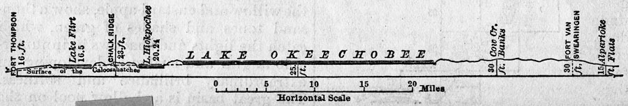
Description: This is a map showing a section of the Lake Okeechobee summit level, circa 1884. It shows water depth along the Lake Okeechobee Summit Level.
Place Names: 1880-1899, Lake Okeechobee
ISO Topic Categories: inlandWaters, environment, location, oceans
Keywords: Section of Basin of Lake Okeechobee, hydrological, water depths, water table, inlandWaters, environment, location, oceans, Unknown,1884
Source: Will Wallace Harney, Harper's New Monthly Magazine: Drainage of the Everglades (New York, NY: Harper & Bros., 1884) 604
Map Credit: Courtesy the Private Collection of Roy Winkelman |
|