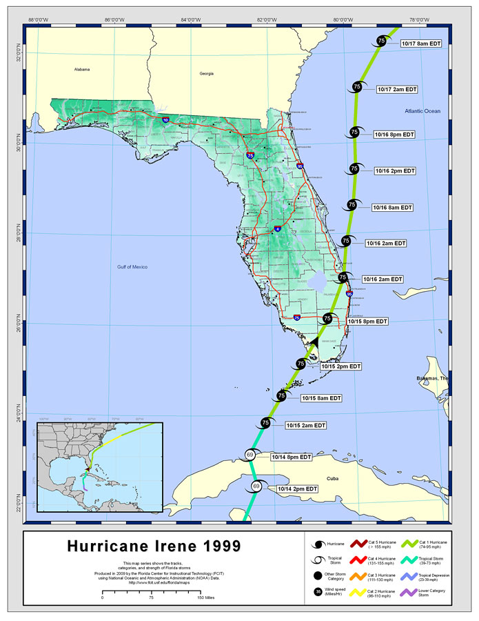
Description: This map created by FCIT shows the track of hurricane Irene in 1999. The legend shows the different categories of hurricanes as follows: Cat 5 (dark red), Cat 4 (red), Cat 3 (orange), Cat 2 (yellow), Cat 1 (green), tropical storm (teal), tropical depression (blue), and lower category (purple). Hence, the color changes when the storm changed categories. Also, the symbols show whether it is a hurricane, tropical storm or other storm category along the track. The data used for this map is from the National Oceanic and Atmospheric Administration (NOAA). This map also shows county boundaries, interstate roads, and some city names.
Place Names: Storms by Name, Bradenton, �Daytona Beach, �Ft. Lauderdale, �Fort Lauderdale, �St. Augustine, �Saint Augustine, �Sarasota, �Gainesville, �Jacksonville, �Key Largo, �Miami, �Naples, �Orlando, �Panama City, �Pensacola, �Tallahassee, �Tampa
ISO Topic Categories: boundaries, �inlandWaters, �oceans, �transportation
Keywords: Storm Tracks by Name: Hurricane Irene, khurricane, �political, �physical, �transportation, �meteorological, country borders, �county borders, roads, boundaries, �inlandWaters, �oceans, �transportation, Albers_Conical_Equal,1999
Source: Florida Center for Instructional Technology, National Oceanic and Atmospheric Administration (NOAA) (Tampa, FL: University of South Florida, 2009)
Map Credit: Courtesy of the Florida Center for Instructional Technology |
|