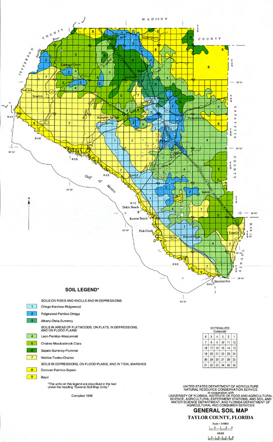
Description: This map shows the nine general soil units found in Taylor County. These soil units are each made up of one or more major soils and some minor soils. The nine general soil units are: Ortega-Kershaw-Ridgewood; Ridgewood-Pamlico-Ortega; Albany-Otela-Surrency; Leon-Pamlico-Wesconnett; Chaires-Meadowbrook-Clara; Sapelo-Surrency-Plummer; Wekiva-Tooles-Chaires; Dorovan-Pamlico-Sapelo; and Bayvi. Major rivers, roads, cities and towns are shown. The Florida township/range grid is used, and the map scale is 1:316800.
Place Names: Taylor, Day, Bucksville, Mayo, Alton, Cooks Hammock, Midway, Hatchbend, Iddo, Shady Grove, Perry, Hampton Springs, Fenholloway, Athena, Salem, Keaton, Steinhatchee
ISO Topic Categories: geoscientificInformation
Keywords: General Soils Map of Taylor County, physical, geological, geoscientificInformation, Unknown,1998
Source: , Soil Survey of Lafayette County, Florida (Washington, DC: USDA, 1998) 311
Map Credit: Courtesy the private collection of Roy Winkelman. |
|