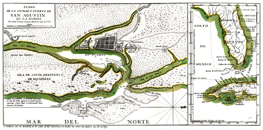
Description: Digitization provided by the USF Libraries Digitization Center. Rare Maps. This is a hand colored map of the Saint Augustine region and its port (puerto) with an insert map of Florida and western Cuba [ca. 1:7,000,000]. This map also shows Fuerte Negro (Fort Mose) which was the first legally sanctioned free black community in present-day U. S. It also shows marshy land (terreno baxo pantanoso), quarries (canteras), sand piles or dunes (bateria de arena), indian villages (villa de indios), and roads (camino). Oriented with north to the right. Relief shown pictorially. Depths shown by soundings, 8 pies equals 8 feet. Measurements.Dimensions: 19 x 28 cm. Coordinates shown are for insert map of Florida and Cuba.
Place Names: 1780-1799, Saint Augustine, Matanzas River, St. Sebastian River, St. Marks River, Gulf of Mexico, Cuba, Cape Canaveral, Anastasia Island
ISO Topic Categories: location, inlandWaters, transportation, oceans
Keywords: Plano de la ciudad y puerto de San Agustin de la Florida, physical, transportation, historical, physical features, roads, location, inlandWaters, transportation, oceans, Unknown,1783 AD
Source: Don Tomas Lopez, (Madrid, : , 1783)
Map Credit: Courtesy of the Special Collections Department, University of South Florida. |
|