mapsExploring Florida
 FL Maps > Local > Hillsborough > The Bay of Espiritu Santo on the Western Coast of East Florida, 1777
Site Map 

The Bay of Espiritu Santo on the Western Coast of East Florida, 1777


Puzzle Directions: Click on a puzzle piece and drag it where you want it. When you connect two pieces correctly, they will join together. Mix up the pieces again. View finished map in pop-up window.

Title: The Bay of Espiritu Santo on the Western Coast of East Florida
Projection: Unknown
Source Bounding Coordinates:
W: E: N: S:

Back to Map Page
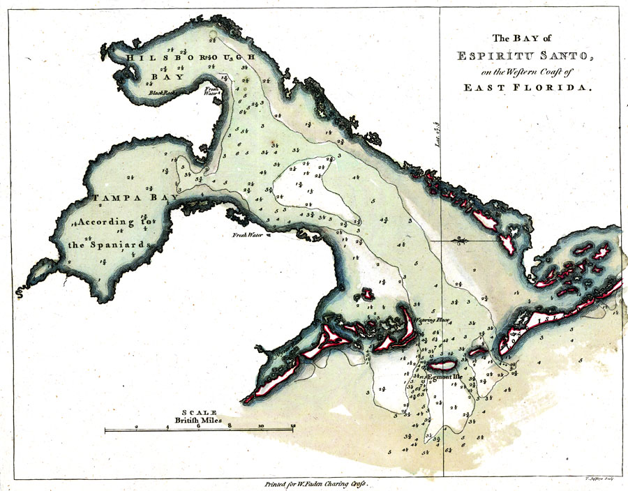
Description: Digitization provided by the USF Libraries Digitization Center. Rare Maps. This is a map of the Bay of Espiritu Santo or Tampa Bay area, circa 1777. Some locations are shown such as fresh water, watering places, Black Rocks, Egmont Isle and Long Island. Oriented with north to the right. Relief shown pictorially. Depths of bay shown in British feet for the Bay of Espriritu Santo.
Source: Thomas D. Jefferys, The North American atlas, selected from the most authentic maps, charts, plans, &c. hitherto published. (London, : William Faden, 1777)
Map Credit: Courtesy of the Special Collections Department, University of South Florida.
SearchLicensePDF HelpGIS Help Google Earth Help Zoomify Help

 FL Maps > Local > Hillsborough > The Bay of Espiritu Santo on the Western Coast of East Florida, 1777