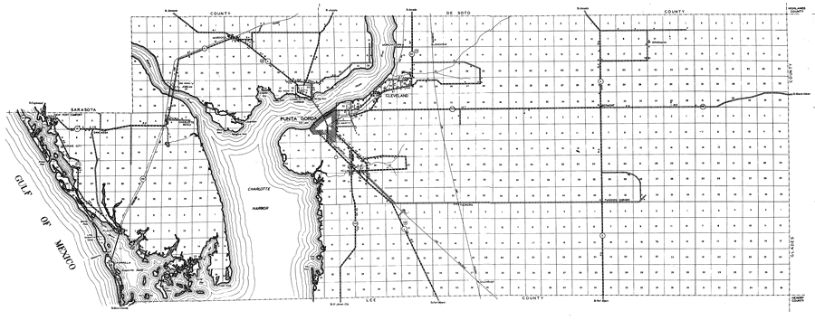
Description: This is a detailed map of the county of Charlotte in the state of Florida. Section Township Range (STR) is shown. This map shows all of the main cities, state roads, US Highways, bridge highways, drawbridge highways, federal aided highway, saw mills, railroads, inland waters, canals, ferries, corporate lines, county boundaries, county seat, camps or lodges, post offices, turpentine stills, cemeteries, seasonal dwellings, churches, farm units, dwellings other than farms, tenant houses, businesses, townhalls, hotels, airports, schools, hospitals and factories. Key to Florida Highway maps.
Place Names: Charlotte, New Port Comfort, Grove City, Sancassa, Charlotte Beach, McCall, Murdock, Gulf of Mexico, Miakka River, Mongrove Point, Punta Gorda, Shoal Point, Alligator Bay, Live Oak Point, Locust Point, Peace River, Cleveland, Morgantown, Charlotte Harbor, Longview, Acline, Bermont, Sparkman, Tuckers Corner, Tuckers, Gasparilla, Placida, Turtle Bay, Cape Haze, Gasparilla Pass, Gasparilla Sound, El Jobean, Gilchrist
ISO Topic Categories: boundaries, inlandWaters, location, transportation, oceans
Keywords: Charlotte, physical, political, transportation, physical features, major political subdivisions, county borders, local jurisdictions, roads, railroads, boundaries, inlandWaters, location, transportation, oceans, Unknown,1936
Source: , Florida State Road Department (, FL: , 1936)
Map Credit: Courtesy the private collection of Roy Winkelman. |
|