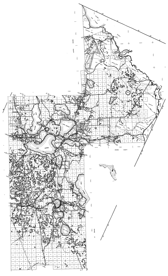
Description: This is a detailed map of the county of Lake in the state of Florida. Section Township Range (STR) is shown. This map shows all of the main cities, state roads, US Highways, bridge highways, drawbridge highways, federal aided highway, saw mills, railroads, inland waters, canals, ferries, corporate lines, county boundaries, county seat, airports, camps or lodges, post offices, turpentine stills, cemeteries, forest ranger lookout station, seasonal dwellings, churches, farm units, dwellings other than farms, tenant houses, businesses, townhalls, hotels, schools, hospitals and factories. Key to Florida Highway maps.
Place Names: Lake, Lake George, Arredondo Grant, Lake Dexter, Huertas Grant, Fernandez Grant, Levy Grant, Lake Norris, St. Johns River, Umatilla, Paisley, Cassia, Mount Plymouth, Sorrento, Mount Dora, Lake Dora, Lake Beauclair, Pittman, Johnson's Corner, Lake Eustis, Lake Yale, Lake Griffin, Tavares, Emeralda, Lake Harris, Lady Lake, Fruitland Park, Leesburg, Whitney, Lisbon, Orange Bend, Lanier, Astatula, Cason, Lake Apopka, Montverde, Ferndale, Lake Minneola, Minneola, Mohawk, Lake Louisa, Groveland, Mascotte, Clermont, Bay Lake, Withlacoochee River, Astor, Grant Island, Eustis, Fullerville, Altoona, Okahumpka
ISO Topic Categories: boundaries, location, transportation, inlandWaters
Keywords: Lake, physical, political, transportation, physical features, major political subdivisions, local jurisdictions, roads, railroads, boundaries, location, transportation, inlandWaters, Unknown,1936
Source: , Florida State Road Department (, FL: , 1936)
Map Credit: Courtesy the private collection of Roy Winkelman. |
|