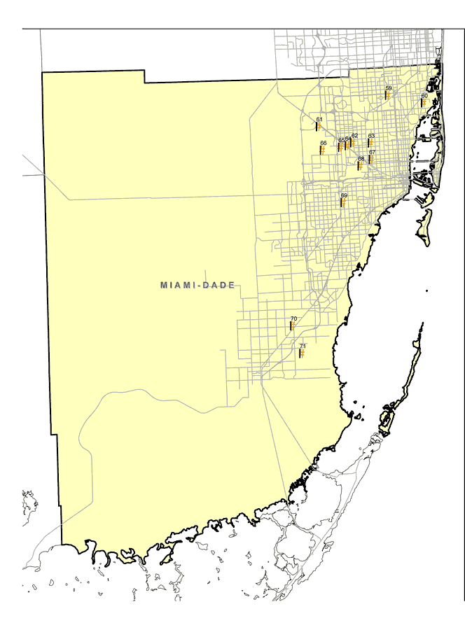
Description: This map shows the locations of Miami-Dade County's thirteen Superfund Sites listed on the United States Environmental Protection Agency's National Priorities List (NPL). The map was created based on Environmental Protection Agency (EPA) shapefiles and metadata. Full information about each site, including each site history, narrative, and Agency for Toxic Substances and Disease Registry (ATSDR) information can be found on the U.S. EPA website. The site name, latitude/longitude, and NPL status for the Miami-Dade sites are: | 59 | Anodyne, Inc.
1270 NW 165 Street
North Miami Beach, FL 33169 | NPL: On final NPL
Latitude: 25.923189
Longitude: -80.221531 | | 60 | Munisport Landfill
152nd St. NE and Biscayne Blvd.
North Miami, FL 33161 | NPL: Deleted from NPL
Latitude: 25.908331
Longitude: -80.154169 | | 61 | Pepper Steel and Alloys, Inc.
11100 NW S. River Dr.
Medley, FL | NPL: On final NPL
Latitude: 25.873611
Longitude: -80.353331 | | 62 | Standard Auto Bumper Corp.
2500 West 3rd Court
Hialeah, FL 33010 | NPL: On final NPL
Latitude: 25.844444
Longitude: -80.289721 | | 63 | Anaconda Aluminum Co./Milgo Electronics Corp.
3630 NW 76th St.
Miami, FL | NPL: Deleted from NPL
Latitude: 25.843061
Longitude: -80.256531 | | 64 | B and B Chemical Co., Inc.
875 W 20th St.
Hialeah, FL 33010 | NPL: On final NPL
Latitude: 25.839581
Longitude: -80.300139 | | 65 | Miami Drum Services
7049 NW 70th St.
Miami, FL 33166 | NPL: On final NPL
Latitude: 25.837219
Longitude: -80.313061 | | 66 | Northwest 58th Street Landfill
NW 58th St.
Hialeah, FL 33012 | NPL: Deleted from NPL
Latitude: 25.833331
Longitude: -80.347219 | | 67 | Airco Plating Co.
3636 NW 46th Street
Miami, FL 33142 | NPL: On final NPL
Latitude: 25.8152
Longitude: -80.2559 | | 68 | Varsol Spill
Miami Int'l Airport
Miami, FL 33159 | NPL: Deleted from NPL
Latitude: 25.8047
Longitude: -80.2772 | | 69 | Gold Coast Oil Corp.
2835 SW 71st Ave.
Miami, FL | NPL: Deleted from NPL
Latitude: 25.7434
Longitude: -80.3112 | | 70 | Woodbury Chemical Co. (Princeton Plant)
13920 SW 248th St.
Princeton, FL 33032 | NPL: Deleted from NPL
Latitude: 25.5367
Longitude: -80.4124 | | 71 | Homestead Air Force Base
Florida Turnpike East
Homestead Air Force Base, FL | NPL: On final NPL
Latitude: 25.489444
Longitude: -80.396944 |
Place Names: Dade, Miami, Homestead, Hialeah
ISO Topic Categories: environment, health, inlandWaters, society
Keywords: Miami-Dade EPA Superfund Sites, physical, political, Hazardous Waste Sitephysical features, county borders, environment, health, inlandWaters, society, Albers_Conical_Equal,2008
Source: Florida Center for Instructional Technology, (Tampa, FL: FCIT, 2008)
Map Credit: Courtesy Roy Winkelman |
|