mapsExploring Florida
 FL Maps > Region > 1950-1999 > Generalized Thickness of the Surficial Aquifer System in Southwest Florida, 1996
Site Map 

Generalized Thickness of the Surficial Aquifer System in Southwest Florida, 1996


Puzzle Directions: Click on a puzzle piece and drag it where you want it. When you connect two pieces correctly, they will join together. Mix up the pieces again. View finished map in pop-up window.

Title: Generalized Thickness of the Surficial Aquifer System in Southwest Florida
Projection: Albers_Conical_Equal
Source Bounding Coordinates:
W: -82.75 E: -81.75 N: 27.75 S: 26.75

Back to Map Page
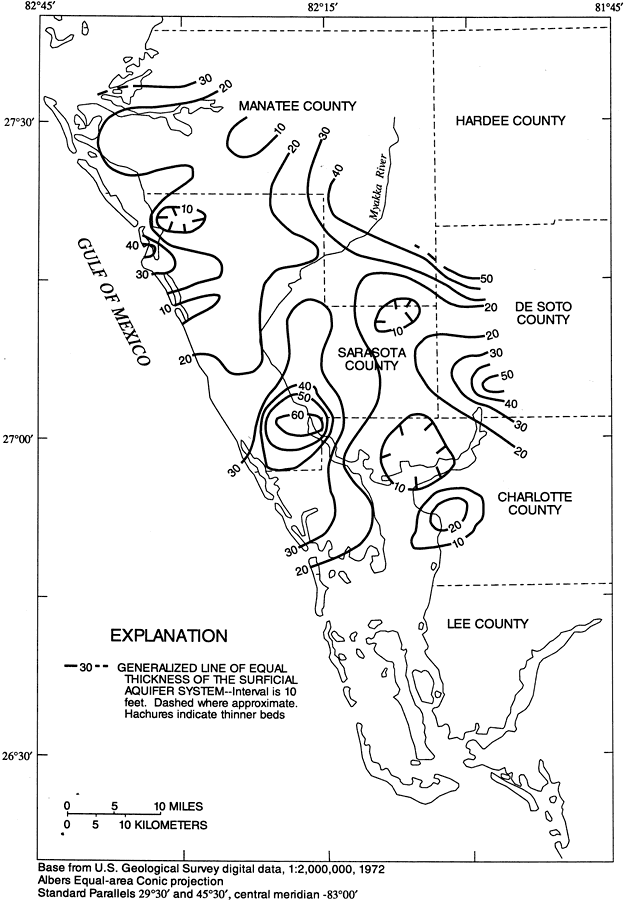
Description: This map from the U. S. Geological Survey Water Resources Investigation Report number 96-4063, Hydrology of the Surficial and Intermediate Aquifer Systems in Sarasota and Adjacent Counties, shows the generalized thickness in feet of the surficial aquifer system in Sarasota and adjacent counties. In the study area of the southwest region of Florida, the Upper Floridan aquifer is overlain by a surficial aquifer system and an intermediate aquifer system made up of 3 distinct permeable zones separated by confining units. The map scale is 1:2,000,000.
Source: G. L. Barr, USGS Water Resources Investigations Report 96-4063 (Tallahassee, FL: U. S. Geological Survey, 1996) 34
Map Credit: Courtesy the University of South Florida Library
SearchLicensePDF HelpGIS Help Google Earth Help Zoomify Help

 FL Maps > Region > 1950-1999 > Generalized Thickness of the Surficial Aquifer System in Southwest Florida, 1996