mapsExploring Florida
 FL Maps > Region > 1950-1999 > Distribution of Recharge and Discharge of the Upper Floridan Aquifer in the Greater Orlando Metropolitan Area, 1996
Site Map 

Distribution of Recharge and Discharge of the Upper Floridan Aquifer in the Greater Orlando Metropolitan Area, 1996


Puzzle Directions: Click on a puzzle piece and drag it where you want it. When you connect two pieces correctly, they will join together. Mix up the pieces again. View finished map in pop-up window.

Title: Distribution of Recharge and Discharge of the Upper Floridan Aquifer in the Greater Orlando Metropolitan Area
Projection: Unknown
Source Bounding Coordinates:
W: -81.45 E: -80.50 N: 28.55 S: 28.15

Back to Map Page
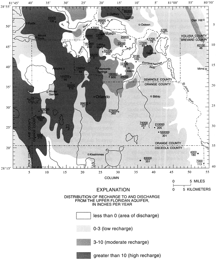
Description: This map from the U. S. Geological Survey Water Resources Investigation Report number 96-4181, Hydrogeologic Conditions and Simulation of Ground Water Flow in the Greater Orlando Metropolitan Area, shows the generalized distribution of recharge to and discharge from the Upper Floridan aquifer in inches per year. The transmissivity is shown next to well sites, with the upper number representing the well's transmissivity in feet squared per day, and the bottom number is thickness of aquifer penetrated by pump well, in feet.
Source: L. C. Murray, Jr. and Keith J. Halford, USGS Water Resources Investigations Report 96-4181 (Tallahassee, FL: U. S. Geological Survey, 1996) 14
Map Credit: Courtesy the University of South Florida Library
SearchLicensePDF HelpGIS Help Google Earth Help Zoomify Help

 FL Maps > Region > 1950-1999 > Distribution of Recharge and Discharge of the Upper Floridan Aquifer in the Greater Orlando Metropolitan Area, 1996