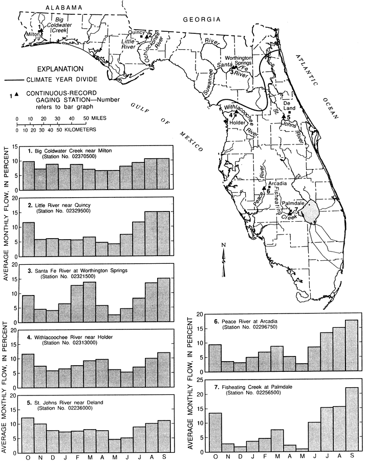
Description: This map from the U. S. Geological Survey Water Resources Investigation Report number 93-4165, Low-Flow Characteristics of Florida Streams, shows monthly variation of streamflow at seven gaging stations in percentage of average annual flow between 1957 and 1987. The climate year divide for low flow is shown with a heavy black line. Two different climatic years were used to determine annual low-flow values, with climatic year beginning on April 1 being used in the north and panhandle because the lowest flow in the region generally occur in October, November, and December, and climactic year beginning on October 1 being used in central and south Florida because the seasonal low-flows generally occur in April, May, and June. The rivers shown are the Big Coldwater Creek, Little River, Santa Fe River, Withlacoochee River, St. Johns River near Deland, Peace River, and Fisheating Creek. The graphs are visual representations of the data, with the average monthly flow, in percent shown on the vertical axis, and the months October through September on the horizontal axis.
Place Names: 1950-1999,
ISO Topic Categories: boundaries, inlandWaters, oceans
Keywords: Monthly Variation of Streamflow, physical, political, hydrological, streamflow, khydroligical, physical features, major political subdivisions, county borders, drainage basins, boundaries, inlandWaters, oceans, Unknown,1957 to 1987
Source: Roger P. Rumenik and J. W. Grubbs, USGS Water Resources Investigations Report 93-4165 (Tallahassee, FL: U. S. Geological Survey, 1996) 7
Map Credit: Courtesy the University of South Florida Library |
|