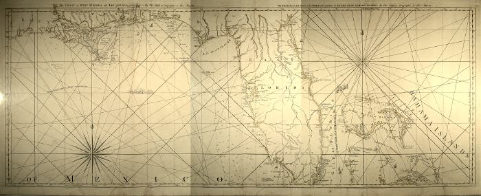
Description: The full title of this map is "The Coast Of West Florida and Louisiana By Thos. Jefferys Geographer to His Majesty. The Peninsula and Gulf of Florida or Channel of Bahama with the Bahama Islands." This is primarily a navigational chart with soundings and rhumblines shown in the gulf and ocean. Coastal features and hazards are noted and shown in detail. Many of the names reflect British occupation, such as Ponce de Leon Bay at the the southwestern tip of the peninsula being labeled Chatham Bay. Lake Okechobee is labeled Spiritu Santo Lagoon. The route from St. Augustine to St. Marks of Apalache is shown. Relief shown pictorially. "The Soundings along the Florida Coast, Shoals, Islands and Reefs are in Feet, except where otherwise expressed.". Prime meridians: Ferro and London. Digitization provided by the USF Libraries Digitization Center. Rare Maps.
Place Names: 1760-1779, Pensacola, St. Andrews Bay, Bay of St. Rose, Santa Rosa Bay, St. Marks of Apalache, Tampa Bay, Bay of Spiritu Santo, Charlotte Haven, Charlotte Harbor, Spiritu Santo Lagoon, Lake Okeechobee, Chatham Bay, Punjo Bay, Ponce de Leon Bay, Lake Sandwich, Cape Florida, St. Matheo, St. Augustin, Saint Augustine, Cape Canaveral,
ISO Topic Categories: inlandWaters, oceans, society
Keywords: The coast of West Florida and Louisiana. , physical, transportation, historical, physical features, water routes, inlandWaters, oceans, society, Unknown,1775
Source: Thomas Jefferys, The American atlas (London, : Sayer and Bennett, 1775)
Map Credit: Courtesy of the Special Collections Department, University of South Florida |
|