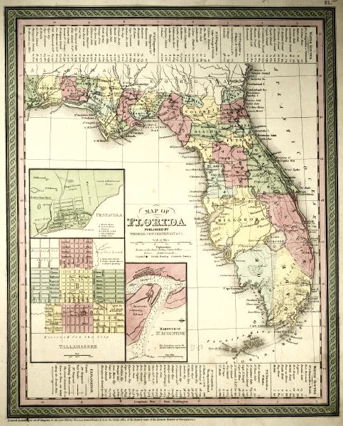
Description: This 1850 map from the New Universal Atlas shows towns, forts, roads, canals, major rivers and lakes in Florida. There are references to forts, battlefields, and routes used by the Army during the Seminole War. There are also three inset maps detailing Pensacola, Tallahassee, and St. Augustine. Water routes from St. Augustine and Pensacola to various ports are described along the upper and lower margins. The map is very similar to the 1839 map from Tanner's Universal Atlas. On this map, Mosquito County has been divided into Orange County and St. Lucie County, and Benton County, which no longer exists, is shown on the Gulf Coast to the north od Hillsborough County. The Longitude is from the Washington Prime Meridian.
Place Names: 1840-1859, Fernandina, Saint Augustine, Tallahassee, Newnamsville, Leigh Read County, Cape Canaveral, Cayo de Boca, Tortugas, Thompsons Island, Key West, Fort Brooke, Pensacola
ISO Topic Categories: boundaries, inlandWaters, oceans, society, transportation
Keywords: Florida, physical, political, transportation, historical, physical features, county borders, roads, other military, boundaries, inlandWaters, oceans, society, transportation, Unknown,1850
Source: Samuel Augustus Mitchell, A New Universal Atlas (Philadelphia, PA: Thomas, Cowperthwait & Co., 1850) 21
Map Credit: Courtesy the private collection of Roy Winkelman |
|