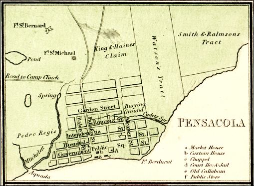
Description: This is a detail of a map that shows Florida current to 1850. The detail highlights Pensacola. There are streets depicted, as well as a burying ground and public square. There is a legend to detail the major institutions of the township. Minor waterways are shown, such as springs, inlets, and ponds. The land is divided into claims and tracts including the Smith & Ralmsons Tract, the Watson's Tract, and the King& Haines Claim. There is also a road that leads to Camp Clinch.
Place Names: Escambia, Pensacola, Camp Clinch, Gulf of Mexico,
ISO Topic Categories: inlandWaters, oceans, transportation
Keywords: Detail - Map of Florida, physical, transportation, physical features, roads, inlandWaters, oceans, transportation, Unknown,1850
Source: , (Philadelphia, PA: Thomas, Cowpwerthwait & Co, 1850)
Map Credit: Courtesy of the Special Collections Department, University of South Florida. |
|