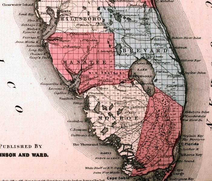
Description: This is a detail from Johnson's Florida map, circa 1860, showing the southern Florida peninsula. It shows counties of the period in color, towns, villages, county seats, forts such as forts Brooke, Dulaney, Center, Shackleford, and Ft. Poinsett, Army roads between forts, inland waters such as the Caloosahatchee River and Lake Okeechobee, and Section Township Range (STR). There are several references to Native American lands in this detail, and battle sites from the Seminole wars.
Place Names: 1860-1879, Gulf of Mexico, Atlantic Coast, Tampa, Ft. Brooke, Ft. Mead, Ft. Myakka, Ft. Crawford, Charlotte Harbor, Ft. Myers, Ft. Dulaney, Ft. Denaud, Ft. Center, Ft. Thompson, Ft. McRae, Ft. Jupiter, Ft. Lauderdale, Ft. Doane, Ft. Simon, Ft. Shackleford, Ft. Keas, Ft. Poinsett, Fort Myers, Fort Lauderdale, Ft. Arbuckle, Ft. Kissimmee, Ft. Pierce, Ft. Van Swearengen, Lake Okeechobee
ISO Topic Categories: boundaries, inlandWaters, oceans, transportation
Keywords: Detail - Johnson's Florida, physical, political, historical, transportation, physical features, county borders, roads, boundaries, inlandWaters, oceans, transportation, Unknown,1860
Source: Johnson, A.J., Johnson's New Illustrated Family Atlas (New York, NY: Johnson and Browning, 1860) 40
Map Credit: Courtesy the private collection of Roy Winkelman. |
|