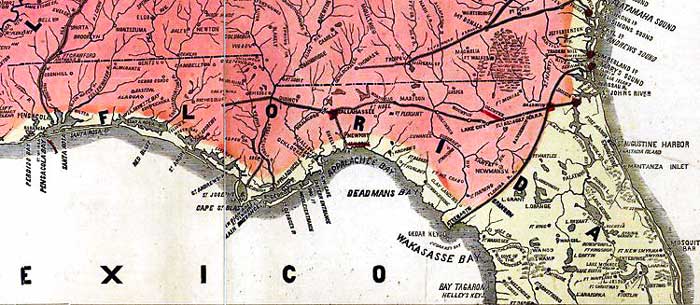
Description: This detail from Lloyd's 1865 map shows Rebel and Union held territories in Florida's panhandle and northern peninsula. The territory held by the Rebels as of April 1, 1865 is shown in red, the territory gained from Rebels since January 1, 1862 is shown in yellow. Battle fields such as Olustee, St. Marks, and Fort Pickens are underlined in red, with red dots at Tallahassee, Baldwin, Jacksonville, and Fernandina indicating strategic places. Railroad lines are shown, with the Florida R.R. between Fernandina and Cedar Keys acting as the border between Rebel-held and Union-held territories on the peninsula. Several Civil War era forts are shown.
Place Names: 1860-1879, St. Marys Sound, Fernandina, Ft. Clinch, Jacksonville, Saint Augustine, Mosquito Bar, Palatka, Ft. New Smyrna, Ft. Christmas, Ft. Catlin, Ft. Lane, Ft. Maitland, Ft. Butler, Ft. Armstrong, Ft. McClure, Ft. Cross, Ft. King, Ft. Hartlee, Ft. Moniac, Ft. Macomb, Ft. Fanning, Ft. McCrab, Ft. Frankbrooke, Ft. Hurlbut, Ft. Barker, Ft. Andrews, Ft. Plesant, Ft. Noel, Ft. Pickens, Ft. McRea
ISO Topic Categories: boundaries, inlandWaters, oceans, society, transportation
Keywords: Detail - Lloyd's new military map of the border & southern states , physical, political, transportation, historical, physical features, major political subdivisions, local jurisdictions, railroads, Civil War, boundaries, inlandWaters, oceans, society, transportation, Unknown,1865
Source: Drawn by Edward S. Hall. Waters & Sons, engravers, (New York, NY: H. H. Lloyd & Co., 1865)
Map Credit: Courtesy of the Geography and Map Division of the Library of Congress |
|