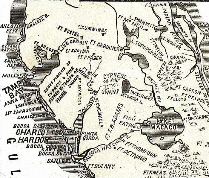
Description: This detail from Lloyd's 1865 map shows Union held territories in Florida's central peninsula. The territory gained from Rebels since January 1, 1862 is shown in yellow. Several Civil War era forts are shown. Lake Okeechobee is shown as Lake Macaco.
Place Names: 1860-1879, Anclote Keys, Tampa Bay, Ft. Cummings, Ft. Foster, Ft. Gardiner, Ft. Sullivan, Ft. Frazier, Ft. Anna, Cape Canaveral, Ft. McNeil, Ft. Taylor, Ft. Capron, Ft. Peirce, Ft. Lloyd, Ft. Bassinger, Anna Maria Key, Ft. Mendo, Ft. Mayakka, Ft. Chiconicla, Charlotte Harbor, Ft. T.B. Adams, Lake Macaco, Lake Okeechobee, Ft. Swearington, Ft. Dulany, Ft. Thompson, Ft. Deynaud, Ft. Kneas, Ft. Jupiter
ISO Topic Categories: boundaries, inlandWaters, oceans, society, transportation
Keywords: Detail - Lloyd's new military map of the border & southern states , physical, political, historical, physical features, major political subdivisions, local jurisdictions, Civil War, boundaries, inlandWaters, oceans, society, transportation, Unknown,1865
Source: Drawn by Edward S. Hall. Waters & Sons, engravers, (New York, NY: H. H. Lloyd & Co., 1865)
Map Credit: Courtesy of the Geography and Map Division of the Library of Congress |
|