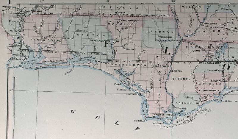
Description: This detail of Asher and Adams' 1871 map of Florida shows county lines and county seats current to the period, major towns and cities, and railroad routes and stations in the Florida panhandle. The railroad routes shown are between St. Marks and Tallahassee, Tallahassee and Chattahoochee Landing, and the route from Tallahassee eastward to Jacksonville. The Township and Range survey grid is shown extending from the Tallahassee Base Line and the Tallahassee Meridian (established in 1824) and the fact that the Forbes Purchase or Forbes Grant in northern Florida was not surveyed in 1871. Digitization provided by the USF Libraries Digitization Center.
Place Names: 1860-1879, Pensacola, Milton, Uchee Anna, Cerro Gordo, Vernon, Marianna, Abe's Spring, Appalachicola, Quincy, Tallahassee, St. Marks, Crawfordville,
ISO Topic Categories: boundaries, inlandWaters, oceans, transportation
Keywords: Detail - Asher & Adams’ Florida, physical, political, transportation, physical features, major political subdivisions, county borders, railroads, boundaries, inlandWaters, oceans, transportation, Unknown,1871
Source: Asher & Adams, Asher & Adams’ new commercial, topographical, and statistical atlas and gazetteer of the United States (New York, NY: Asher & Adams, 1871)
Map Credit: Courtesy of the Special Collections Department, University of South Florida |
|