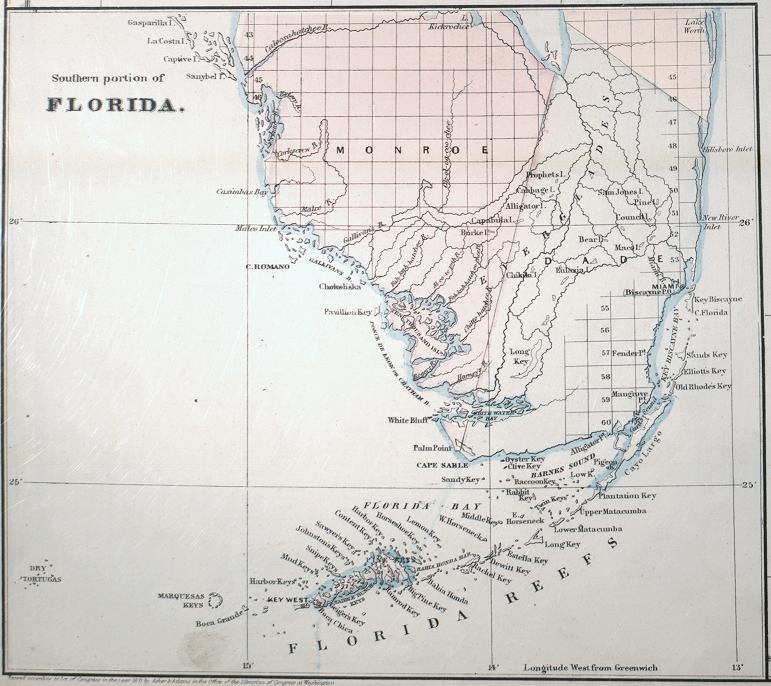
Description: This detail of Asher and Adams' 1871 map of Florida shows county lines and county seats current to the period, major towns and cities in the southern Florida peninsula and Florida keys. The Township and Range survey grid is shown extending from the Tallahassee Base Line and the Tallahassee Meridian (established in 1824) and the fact that much of the Everglades and the Forbes Purchase or Forbes Grant in northern Florida were not surveyed in 1871. Although the Everglades were not surveyed using the Township Range grid, many "island" features are shown in the glades, including Prophets, Cabbage, Sam Jones, Bear, Lulaxia, Chikiki, Capabula, and Burke islands, and a landlocked Long Key. Other interesting points include Miami subtitled "Biscayne P. O." and alternative names for the Florida Keys between Long Key and Bahia Honda Key. These older names include Rachel, Dewitt, Estella, and West and East Horseneck Keys. Digitization provided by the USF Libraries Digitization Center
Place Names: 1860-1879, Miami, Biscayne P.O., Key West, Lake Okeechobee, Dry Tortugas,
ISO Topic Categories: boundaries, inlandWaters, oceans, transportation
Keywords: Detail - Asher & Adamsĺ Florida, physical, political, physical features, major political subdivisions, county borders, boundaries, inlandWaters, oceans, transportation, Unknown,1871
Source: Asher & Adams, Asher & Adamsĺ new commercial, topographical, and statistical atlas and gazetteer of the United States (New York, NY: Asher & Adams, 1871)
Map Credit: Courtesy of the Special Collections Department, University of South Florida |
|