Maps Site map
  FL Maps > State > 2000-
Site Map  

  Record   51   to   55  of   55

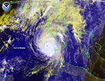
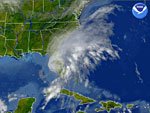
Hurricane Charley Approaching Florida, August 13, 2004
This is a satellite image showing Hurricane Charley approaching the Florida coast on August 13, 2004 at 11:15 AM. The National Hurricane Center estimated sustained winds up to 95 mph with gusts up to 115 mph and movement to the north at 16 mph....

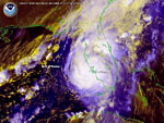
Hurricane Charley Approaching Ft. Myers, August 13, 2004
This is a satellite image showing Hurricane Charley approaching Ft. Myers on August 13, 2004 at 3:15 PM. The National Hurricane Center estimated winds up to 145 mph near the eye of the storm and movement to the north-northeast at 20 mph....

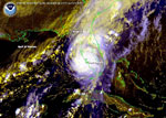
Hurricane Charley Making Landfall, August 13, 2004
This is a satellite image showing Hurricane Charley located just northwest of Ft. Myers on August 13, 2004 at 4:15 PM....

Florida Fires, May 19, 2001
This is a satellite image showing the fires across Florida on May 19, 2001. According to news sources, there were nine large fires burning in Florida on May 19 and as many as fifteen fires burning on May 21....

Tropical Storm Gabrielle, September 14, 2001
This is a satellite image showing the position of Tropical Storm Gabrielle and its movement in Florida on September 14, 2001 at 10:15....

First Previous


  FL Maps > State > 2000-
Site Map  

Maps ETC is a part of the Educational Technology Clearinghouse
Produced by the Florida Center for Instructional Technology © 2007
College of Education , University of South Florida