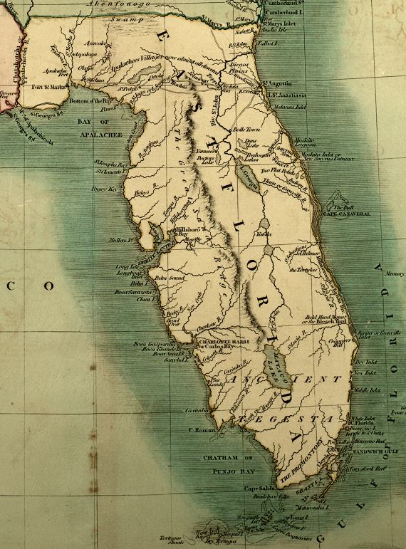
Description: A detail from the 1806 map of the United States showing the Spanish territory of East Florida. This map shows coastal features, major lakes and rivers, and settlements. Relief is shown pictorially. Certain place names reflect English, variations, such as West Key for Key West, Chatham or Punjo Bay for Ponce de Leon Bay, Sandwich Gulf for Biscayne Bay, and Mayaco Lake for Lake Okeechobee. The route between St. Augustine and Fort St. Marks is shown, with a note that "Apalachees Villages now almost all deserted." The full title of the original map is "A new map of part of the United States of North America containing the Carolinas and Georgia. Also the Floridas and part of the Bahama Islands from the latest authorities." Digitization provided by the USF Libraries Digitization Center. Rare Maps.
Place Names: 1800-1819, St. Marys Inlet, St. Augustine, Saint Augustine, Moskito Inlet, Cape Canaveral, Jupiter Inlet, Sandwich Gulf, Cape Florida, Mayaco Lake, Lake Okeechobee, West Key, Key West, Chatham Bay, Punjo Bay, Cape Sable, Cape Roman, Charlotte Harbor, Tampa Bay, Spiritu Santo Bay, Boca Sarazota, Bay of Apalachee, Fort St. Marks, St. Marks, Chatahotcha River, Appalachicola River, Apalachicola Rive
ISO Topic Categories: boundaries, inlandWaters, oceans, society
Keywords: Detail - A new map of part of the United States of North America..., physical, political, historical, physical features, major political subdivisions, boundaries, inlandWaters, oceans, society, Unknown,1806
Source: John Cary, Cary's New Universal Atlas (London, : John Cary, 1808)
Map Credit: Courtesy of the Special Collections Department, University of South Florida |
|