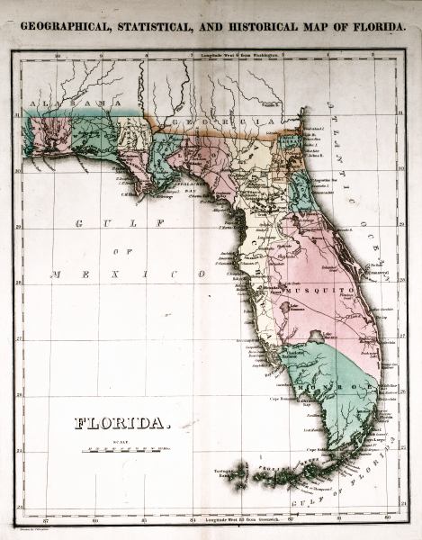
Description: This 1827 map shows major rivers, lakes, coastal features, settlements, and roads in Florida. There are only twelve counties shown: Escambia, Walton, Jackson, Washington, Gadsden, Leon, Alachua, Nassau, Duval, St. Johns, Musquito, and Monroe. The Arredondo, Delespines, Mirandas, and Flemings Spanish land grants are shown. Sections of proposed shipping canals are also shown.
Place Names: 1820-1839, Fernandina, St. Johns River, Saint Augustine, Jacksonville, Deadmans Bay, Tampa Bay, Tallahassee, Cape Canaveral, Cape Florida, Gallivans Bay, Cayo Largo, Key Largo, New Castle Island, Big Pine Key, Thompsons Island, Key West, Cape Romano, Charlotte Harbor, Sanybell Island, Sanibel Island, Fort St. Marks, St. Marks, Appalachicola River, Apalachicola River, Appalachee Bay, Apalachee Bay, Santa Rosa Bay, Pensacola, Lake Macaco
ISO Topic Categories: boundaries, inlandWaters, oceans, transportation
Keywords: Geographical, statistical, and historical map of Florida, physical, political, historical, transportation, physical features, major political subdivisions, county borders, roads, boundaries, inlandWaters, oceans, transportation, Unknown,1827
Source: Joseph Drayton, A complete historical, chronological, and geographical American atlas (Philadelphia, PA: Carey and Lea , 1827) Plate 37
Map Credit: Courtesy of the Special Collections Department, University of South Florida |
|