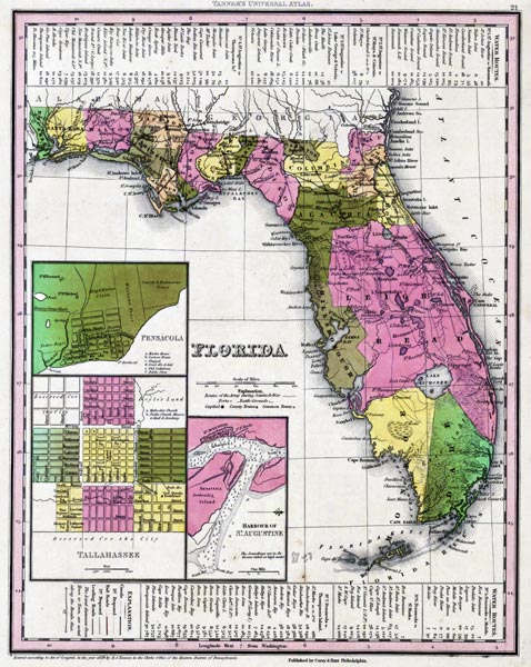
Description: This map from the Tanner's Universal Atlas shows towns, forts, roads, canals, major rivers and lakes in Florida. There are references to forts, battlefields, and routes used by the Army during the Seminole War. There are also three inset maps detailing Pensacola, Tallahassee, and St. Augustine. Water routes from St. Augustine and Pensacola to various ports are described along the upper and lower margins. Mosquito County is shown as Leigh Read County on this map, a name change that was proposed by the State Legislature, but was never officially adopted. The Longitude is from the Washington Prime Meridian.
Place Names: 1820-1839, Fernandina, Saint Augustine, Tallahassee, Newnamsville, Leigh Read County, Cape Canaveral, Cayo de Boca, Tortugas, Thompsons Island, Key West, Fort Brooke, Pensacola
ISO Topic Categories: boundaries, inlandWaters, oceans, society, transportation
Keywords: Florida, physical, political, transportation, historical, physical features, county borders, roads, other military, boundaries, inlandWaters, oceans, society, transportation, Unknown,1839
Source: Henry Schenck Tanner, Tanner's Universal Atlas (Philadelphia, PA: Carey & Hart, 1839) 21
Map Credit: Courtesy the private collection of Roy Winkelman |
|